
Idaho State Grad Student Lives In Wilderness For Transpiration Study
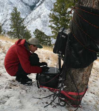
John Whiting downloads data at a mixed precipitation sap flow site within Pioneer Creek watershed in the Frank Church River of No Return Wilderness. The black fabric covering the equipment enclosure and a section of the Douglas Fir trunk is for camouflage from potential hikers or hunters that come through the area, but also seems to keep bears from tearing into the equipment. The white sensor hanging off the tree is a temperature and relative humidity sensor which allows for calculating vapor pressure deficit. The sap flow sensors are insulated underneath the black fabric and other insulating layers around the tree trunk. (Credit: Chris Connors)
In order to get the data he needed for his graduate research project, John Whiting had to do a little camping. But this was no weekend research project – he spent more than three months collecting measurements in a wilderness area near Idaho’s Frank Church River.
The goal of his research was to measure the impacts that snowpack had on water availability for Douglas Fir trees, the most wide-ranging tree in central Idaho. Data collected would also help answer questions relating to the health of streams and fish in the Pioneer Creek Watershed, as well as ecological effects downstream. He was assisted by Sarah Godsey, a professor of geosciences at Idaho State, and Dylan Refaey, an undergraduate field assistant at the school.
Three sites were chosen for the investigation. One was in an area where rain is the dominant type of precipitation. Another was in an area that gets all of its water from snow. The last was set up in an area that gets a mix of rain and snow year round.
Each site consisted of three Douglas Firs equipped with custom sap flow sensors that reported measurements to data loggers. Whiting explains that eddy flux towers can also be used to measure plant transpiration. The difference when compared to his approach, he says, is that sap flow sensors allowed him to measure the transpiration of individual trees. Then by relating sap flow measurements to the dimensions of trees nearby, it was possible to make transpiration estimates.

John Whiting works on wiring at a snow-dominated sap flow site within Pioneer Creek Watershed. (Credit: Jesse Bennett)
Scientists also used LI-COR LI-190 PAR sensors to track photosynthetically active radiation, Decagon soil moisture sensors and Onset Hobo relative humidity and temperature loggers. The technology helped capture plant activity, in addition to the movement of moisture.
“We wanted to test the hypothesis: Does snow matter?” said Whiting, a research assistant and graduate student of geoscience at Idaho State. In the No Return wilderness, where the study took place, there have been concerns that streams could dry out after other investigations looking at stream ecology and fish health. “We were mapping where flow exists and fluctuates, and where flow is continuous, to see how it affects ecology in the immediate area and downstream.”
Part of studying the flows involved using a Trimble GeoXH GPS handheld, which allowed Whiting to map four watersheds around the creek. From there, scientists took the maps and used them to compare how stream contraction correlated with transpiration data.
But the flow mapping didn’t see huge drops in stream size. And sap flow data across all sites were pretty consistent, researchers found, meaning the impacts of snowpack were small.
“It was consistent across elevations, which is not what we were expecting,” said Whiting. “We expected sap flow to persist longer at higher elevations and then drop off quicker at lower elevations.”
Without contractions in stream size, Whiting says that they were still able to measure decreases in discharge. To explain why the surface flow didn’t fluctuate that much, he guesses that flow heads in the area may be anchored by streams or other features in surrounding bedrock.
“Perhaps water is flowing through deeper aquifers only accessible to trees,” said Whiting. “Clearly there’s more work to be done in the future.”
Top image: John Whiting downloads data at a mixed precipitation sap flow site within Pioneer Creek watershed in the Frank Church River of No Return Wilderness. The black fabric covering the equipment enclosure and a section of the Douglas Fir trunk is for camouflage from potential hikers or hunters that come through the area, but also seems to keep bears from tearing into the equipment. The white sensor hanging off the tree is a temperature and relative humidity sensor which allows for calculating vapor pressure deficit. The sap flow sensors are insulated underneath the black fabric and other insulating layers around the tree trunk. (Credit: Chris Connors)


0 comments