
Michigan Tech’s GLRC Deploys New Buoy In Straits Of Mackinac
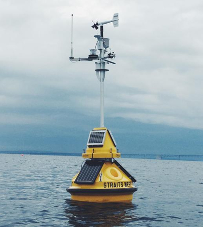
The GLRC buoy deployed in the Straits of Mackinac. (Credit: Michigan Technological University)
The Straits of Mackinac are arguably the most heavily traveled portion of the Great Lakes. Ferries, U.S. Coast Guard vessels and fishing ships all depend on the area where Lake Michigan meets Lake Huron. The complexities of the area are compounded by the shifting currents it sees — they can change from one direction to another within just a few days. And then there’s the oil pipeline, Enbridge’s Line 5, that runs beneath the Straits.
Clearly, tracking environmental changes in the Straits is important and helps those traversing them as well as researchers. But real-time water quality data have been lacking there for some time. Indeed, the closest Great Lakes Observing System buoy sits in Douglas Lake, an inland Michigan water body around 30 miles south of the Straits.
To fill the coverage gap, researchers at Michigan Technological University have deployed a buoy there. Enbridge contracted the school’s Great Lakes Research Center to launch the platform, which took to the water in mid August.
The custom-built buoy is equipped with sensors to measure parameters like wind speed and direction, wind gusts, air temperature, barometric pressure, relative humidity and water surface temperatures. A temperature string deployed beneath the buoy also measures temperature differences of the Straits in a profile, reporting temperature data every 10 feet all the way to the bottom.
Scientists have also added an acoustic doppler current profiler to the platform to measure currents in the Straits. That’s an important sensor to have there, especially given the presence of an oil pipeline.

The S/V Osprey pulls away after Michigan Tech / GLRC scientists deploy the new Straits of Mackinac buoy. (Credit: Enbridge)
“It’s an environmentally sensitive area and there’s an extreme amount of interest with the Enbridge pipeline running beneath it,” said Guy Meadows, director of the GLRC at Michigan Tech. “We want to make sure that everyone is informed. These data are valuable for the shipping industry, commercial fishing and first response if an emergency ever occurs.”
Data collected by the platform will also serve other needs. Meadows says that he and others at the GLRC do routine monitoring of the pipeline and the terrain around it, but can’t always rely on the autonomous underwater vehicle (AUV) they use for that purpose to accurately negotiate the strong surface currents. To complete a successful acoustic imaging mission, they have to pick their days carefully, accounting for weather and other things, to acquire accurate data.
In addition, the new buoy’s data will also help inform sophisticated modeling work going on at the GLRC and the National Oceanic and Atmospheric Administration’s Great Lakes Environmental Research Lab that is trying to pinpoint circulation patterns of Lakes Michigan and Huron.
“We want to do some verification of those models before we can make them fully operational,” said Meadows.
Data from the new buoy will also be shared with the Great Lakes Observing System and posted online for researchers around the basin to use.
“We’ll collect about 2 million readings per year and upload them to the GLOS site,” said Meadows. “Each one can be downloaded and is archived very nicely.”
Top image: The GLRC buoy deployed in the Straits of Mackinac. (Credit: Michigan Technological University)


0 comments