
Modeling Tool Helps Minimize Flood And Landslide Risks After Wildfires
Damage from excess erosion following the 2002 Hayman Fire near Denver, Colorado. (Credit: Mary Miller, Michigan Tech Research Institute)
More than 300 homes were lost in the Waldo Canyon Fire that blazed a few miles from Colorado Springs, Colorado, for nearly a month in 2012. One of them belonged to Mary Miller’s friend.
Miller, a research engineer at Michigan Technological University’s Michigan Tech Research Institute, would go on to volunteer on a Burned Area Emergency Response (BAER) team working to help after the fire. The concern, as is the case after many forest fires, was that the loss of trees and plant life would lead to increases in runoff from the charred slopes, which could lead to flooding. Heightened erosion rates that typically follow forest fires also threatened landslides.
“Due to post-fire flooding and erosion, people lose their lives,” said Miller. “It’s very serious.”
Her volunteer work involved rapidly compiling data on those risks, which she says had to be completed within a few weeks. This was to avoid having to submit an environmental impact statement that could put proposed remediation and risk-reduction methods on hold. It was through that experience that she first got involved with BAER teams and the work of controlling erosion and runoff risks after forest fires.

A smoldering tree. (Credit: Mary Miller, Michigan Tech Research Institute)
An issue she saw was that assessing the risks simply took too long. In a project that is helping to speed things up, Miller is using data from NASA Landsat satellites and BAER teams on the ground to build a nationwide model that can assess erosion and runoff risks faster than old practices. It is in the beginning stages at this point, but has grown from an idea to a web tool covering 17 fire-prone western states.
“What used to take four to five days to assemble data can be done online,” said Miller. “Our database does it in a couple of hours now.”
The Landsat images contribute information on a fire’s burn scar, which is easily viewable from space. From there, Miller assesses which areas look to have been burned more or less severely. This helps BAER teams know how much ground has been exposed by a blaze.
Miller says that BAER teams also gather useful data on the ground to assess burn severity and post-fire surface cover.
“They (BAER teams) may use a water drop test or a mini-disc infiltrometer to measure hydraulic conductivity of the soils (a measure of how fast the water can move in the soil) as they can change post-fire,” said Miller.

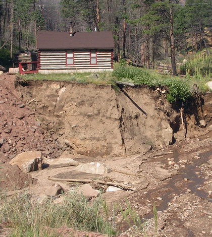
Land subsidence following the 2002 Hayman Fire near Denver, Colorado. (Credit: Mary Miller, Michigan Tech Research Institute)
By combining the remote sensing data and findings gleaned from BAER ground samples with land cover and other conditions, the modeling tool can provide the hydrological inputs so that the BAER teams can respond to predicted runoff impacts quickly. The database also reveals erosion risks, she says.
“For fire remediation, protecting ground cover and the soils might require mulching where there might be risk,” said Miller. Which is exactly what happened after the 2014 King Fire in California. The tool showed how much erosion could be reduced by applying mulch as new ground cover. From there, the BAER team used the data to justify the cost of mulching to state forest officials. “With our modeling data, we saved them millions of dollars,” said Miller.
Moving forward with the work, Miller is looking to continue refining and validating the modeling tool. Part of that will be helped by scientists at Colorado State University, who are completing a related investigation into burn severity’s effect on a watershed. They’re using tipping bucket rain gauges and stream gauges as part of their effort that’s yielding plenty of weather data for Miller to use.
“We’re recreating the climate in the last three years (for their study area), just for the fire data,” said Miller.
The precipitation measurements and flow data are being used in creating a climate file to predict for erosion, Miller says. That will be compared to other such data at similar sites. She has done this type of thing with observations collected at the 2012 High Park Fire, which was a good opportunity for refining the tool’s capabilities.
Miller says it’s important to keep validating and tweaking the model because of the high uncertainties that come along with predicting what will happen after forest fires.
“The uncertainty is huge. On orders of magnitude, we can predict PCBs (polychlorinated biphenyls) in water better. It ranges across the country and there is quite a bit of variability,” said Miller. “The key to my database is preparation ahead of time so that (BAER) teams can rapidly respond with process-based hydrologic models and remote-sensing data.”
Top image: Damage from excess erosion following the 2002 Hayman Fire near Denver, Colorado. (Credit: Mary Miller, Michigan Tech Research Institute)


0 comments