
N.C. stream monitoring network eyes changes in a protected watershed
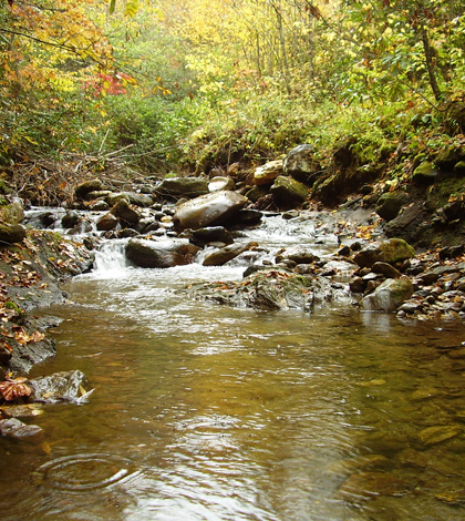
A stream in the Allen's Creek Watershed
Allens Creek runs through the mountains of western North Carolina before delivering clean, clear water to a reservoir that provides the town of Waynesville with drinking water.
One reason the water is so clean it that the town owns all the land in the watershed and manages it to preserve water quality.
“So it’s a fairly undeveloped watershed at this point,” said Jerry Miller, professor of environmental science at West Carolina University. “It has restricted use and entry, and it backs up against National Park Service land.”
The town is considering how the forested watershed might bring them benefits in addition to clean water. The plans include selective timber harvests that could improve the health of the forest while providing the town with logs to sell for revenue. But there is some thought that such harvests could lead to sediment runoff in Allens Creek or its tributaries.
“One of the concerns is that when water is as clean as this is you don’t have to do a whole lot to get a change in water quality,” Miller said. “Those types of systems can actually be pretty sensitive to land use changes and disturbance.”
To track water quality in the watershed and detect the potential effects of timber harvests, the town has partnered with Miller and West Carolina University to establish a network of automated monitoring stations throughout the basin.
A monitoring station installed on the main stem of Allens Creek in 2007 includes an Isco automated sampler and a YSI sonde measuring dissolved oxygen, turbidity, temperature, pH and specific conductivity. The project has since grown to include additional stations with samplers and turbidity sensors on several tributaries.

A stream in the Allens Creek system. The PVC pipe on the right houses YSI sensors.
The data so far have shown very low levels of turbidity and suspended sediment, even during high flows associated with rain events.
The water is so clean, in fact, that they’ve had to get a little clever with the device that triggers one of their automatic samplers. The sampler is equipped with an actuator that, when inundated by rising creek waters, sends the signal to begin filling bottles every 30 minutes to sample the runoff from the storm.
But Miller and his students initially found that this wasn’t actually happening. It turns out the ion content of the water is sometimes so low that it doesn’t conduct enough electricity to complete the circuit in the actuator when it’s submersed.
To get around this problem, Miller and his students came up with a system that keeps the actuator in a cup primed with a drop of saline solution. That boosts the conductivity of the first water to flood into the cup just enough to complete the circuit and trigger the sampler.

Servicing a monitoring station in West Carolina University sensor network in the Allens Creek Watershed
At its longest-running station, the network has provided six years of sediment and turbidity data to serve as a baseline against which researchers can detect changes brought on by new land uses in the forest. It has also provided university students with a chance to gain experience with scientific instrumentation and data analysis.
It’s all the result of what Miller said is a mutually beneficial relationship with the town of Waynesville.
“They’re getting some useful information that should help them improve the management of their drinking water supply,” Miller said. “We get a lot out of it, in that it helps support the education of our students.”


0 comments