
NASA Airborne Snow Observatory ensures West’s water data grows with water demand
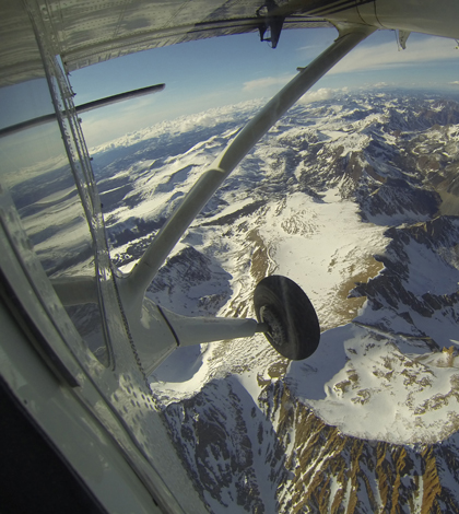
The view from a Twin Otter aircraft carrying NASA's Airborne Snow Observatory on April 3, 2013, as it flies over Mt. Dana and Dana Plateau in the Tuolumne River Basin within Yosemite National Park, Calif. (Credit: NASA/JPL-Caltech)
In some parts of the United States, the demand for water is quickly outgrowing its supply. As climate change and prolonged drought worsen the issue, scientists at NASA are taking to the skies to more accurately monitor available water reserves in the form of fallen snow.
About 80 percent of the western states’ water supply comes from mountain snowpack. NASA’s new Airborne Snow Observatory is supplying scientists and water managers with the most accurate measurements ever of how much water is locked up in snowpack. Before 2012, however, there was no means of effectively measuring the volume and melt rate of that snow.
“The way that snow information has been had for science — as well as for water management — is pretty much the same as it has been for the last century,” said Thomas Painter, a scientist at the California Institute of Technology’s Jet Propulsion Laboratory.
The standard methodology is simple, Painter said. Water resource agents ski to mountain sites armed with snow tubes and scales, collect snow at index sites, then weigh them to determine the volume of water present in the snowpack.
By using a 10- to 30-year average of the gathered data, water managers can estimate runoff rates and predict how much water will be available in a given year. These figures, Painter said, are rough at best — and until the mid-20th century, that was okay.
But as population greatly rose in the latter half of the century, so too did the value of water information for both water managers and scientists. But the runoff estimates produced by water manager weren’t designed for hydrology, and provide little use in determining important chemical and physical properties of snow.
“The best that we have been able to do as snow hydrologists is use the information that water managers produce and interpret the bejeezus out of it,” Painter said.
Painter recognized that the lack of knowledge was holding scientists back, and that a new means of monitoring was necessary. The emerging employment of satellites in the last few decades proved to be useless in obtaining snow water equivalence over mountains. Microwave emissions technology fared no better: the jagged mountain terrain rendered the instruments ineffective.
“I had a burr under my saddle,” Painter said. “I needed to do this. No one else was doing this.”
Influenced by projects at the National Ecological Observatory Network and the Carnegie Institution, Painter took his vision to NASA’s Jet Propulsion Laboratory. In a few short years, that vision became reality.
“In the summer of 2012 we put an imaging spectrometer — which measures reflective sunlight in a few hundred colors — onto a plane along with a scanning LiDAR.” The resulting system was the Airborne Snow Observatory, a monitoring system that collects snow data equally useable by scientists and managers.
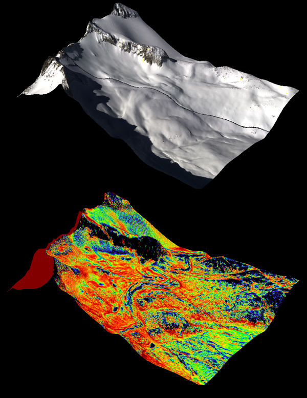
(Top) A natural color image of Mt. Lyell in the Tuolumne River Basin. (Bottom) A color composite image of snow depth on Mt. Lyell from NASA’s Airborne Snow Observatory (Credit: NASA JPL/Caltech)
The spectrometer and LiDAR units peer out of the Twin Otter plane through a 6-foot hole in its floor. Together, the instruments monitor the spatial distribution of the snow water equivalent, along with albedo–vital in calculating how quickly snow will melt. However, albedo has only recently been recognized as a key factor in that equation.
“We’ve been blind to the thing that drives the economy out here,” Painter said regarding albedo’s importance. “Despite popular perception, the thing that drives snowmelt in the spring is absorbed sunlight, not temperature.” All in all, temperature provides only five percent of the energy to melt snow.
For its first trial, the Observatory flew across two important river basins in the U.S. west: the Tuolumne, which supplies water for the city of San Francisco, and the Uncompahgre in Colorado. Covering about 500 square miles in combined area, the basins were first observed without snow to establish a baseline terrain, and then on a weekly basis after the initial snowfall.
The Observatory cost $1.4 million to operate from April to June 2013, but Painter said the benefits of the system exceed its expense.
“Consider that more than a tenth of the population of the U.S. gets its water supply from the Colorado River,” Painter said. “We have about $1.5 trillion in the economy that is contingent on that.” He added: “We haven’t even really figured out the full value of this. In a year or so we should have a much better idea.”
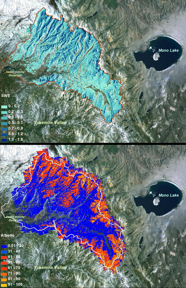
Top: Airborne Snow Observatory measurements of snow water equivalent, or the the total water contained as snow, over the Tuolumne River Basin in California. Bottom: Snow albedo for the same area. (Credit: NASA/JPL-Caltech)
The Airborne Snow Observatory will also help scientists examine the effectiveness of cloud seeding, a method of weather modification in which chemicals such as salt and silver iodide are dispersed into the air in an attempt to affect precipitation.
Although the Airborne Snow Observatory is already on track to drastically improve snow hydrology and water management, Painter said that the current system is only the beginning. The Sierra Nevada might eventually see three Observatory systems performing regular monitoring in the area. Operations in South America have also been considered.
Ultimately, NASA hopes to use the technology of the Airborne Snow Observatory in a satellite application, granting the system global effectiveness.
“That’s what NASA does: new science that nobody else has done,” Painter said. “We’re going to get there — it may be 15 years, it may be 25 years, but we will definitely get there.”
Top image: The view from a Twin Otter aircraft carrying NASA’s Airborne Snow Observatory on April 3, 2013, as it flies over Mt. Dana and Dana Plateau in the Tuolumne River Basin within Yosemite National Park, Calif. (Credit: NASA/JPL-Caltech)


0 comments