
NASA, USGS Team Up To Ground-Truth PRISM Sensor
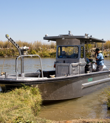
The U.S. Geological Survey R/V Mary Landsteiner shown at a brief stop during a study in the Northern San Francisco estuary. USGS scientist Bryan Downing is shown calibrating the on-board, real-time underway measurement system. (Credit: Stephen de Ropp for the U.S. Geological Survey)
Monitoring water quality in inland bays and estuaries is tricky even over the short term. Conditions can shift quickly, not in days or weeks — but within minutes.
Because of that variability, a number of research efforts have tried their hand at eliminating it using remote sensors. Most of these rely on light penetration and reflectance to see what we can’t see with the naked eye.
One of the most recent efforts to minimize this uncertainty through remote sensing relied on a collaboration between the U.S. Geological Survey and NASA’s Jet Propulsion Laboratory. Scientists from both organizations paired off into two teams to study the dynamics of water quality in San Francisco Bay. One group completed manual sampling of the bay while the other conducted flights over the area in an aircraft equipped with the new PRISM sensor (portable remote imaging spectrometer).
The ultimate goal of the work was to vet the reliability of the PRISM sensor for deployment on satellites in the future.
“The question we were seeking to answer was: Can we do this at all?” said Brian Bergamaschi, biogeochemist with the U.S. Geological Survey. He is also a co-author on an article detailing the study’s results published in the journal Environmental Science and Technology. “…The tides, if you take a picture right now and then take a picture 20 minutes from now. They will look very, very different.”
His end of the work dealt with taking measurements on the ground from San Francisco Bay. This involved speeding around the bay with a sampling system designed for taking water quality measurements at high speed. The approach is similar to that of the FLAMe sampler, a high-speed rig also developed by the U.S. Geological Survey but is more commonly deployed on lakes and targets different parameters.

U.S. Geological Survey scientists (from left) Judy Drexler, Tamara Kraus and Bryan Downing and Katy O’Donnell preparing to take spot field measurements in the San Francisco estuary. (Credit: Stephen de Ropp for the U.S. Geological Survey)
“The FLAMe sampler has a different suite of measurements,” said Bergamaschi. “We’re using the same sort of idea. But they have a cooler name.”
For this effort, Bergamaschi says that he and others working in the bay were primarily concerned with total suspended sediments, turbidity, methylmercury, dissolved organic carbon and levels of chlorophyll.
“In estuaries, things change quickly over space and time. You have to take measurements quickly,” said Bergamaschi. “Our boat was equipped to do that with various optical instruments to calibrate what the satellite should see, the actual, specific properties of the stuff in the water. Fifteen different instruments.”
This high-speed approach was complemented by manual sampling in the bay, as well as lab analysis of water samples. From there, ground data were compared to those gathered by the aircraft-mounted PRISM sensor.
The results were excellent, Bergamaschi says. For all of the parameters that they were interested in, the sensor was able to tease apart different colors in the images it collected and identify what they were.
“We’re surprised it worked as well as it did. It’s a pretty expensive thing to do, but we wouldn’t have done it if we weren’t confident that it would work,” said Bergamaschi. “It’s a pretty forward-looking project.”
In the bay, he says, the results will prove useful for improving the understanding of its dynamics. A number of efforts keep track of conditions in deep parts of San Francisco Bay, but the shallows are not as well studied. “It opens up a geography that we didn’t have access to before,” said Bergamaschi.
The findings may also help monitor the water quality in other inland bays and coastal areas of the United States. Any nearshore environment with high turbidity levels could benefit, Bergamaschi says. In the future, he is looking to apply some of the same techniques to lakes in Alaska.
Top image: The U.S. Geological Survey R/V Mary Landsteiner shown at a brief stop during a study in the Northern San Francisco estuary. USGS scientist Bryan Downing is shown calibrating the on-board, real-time underway measurement system. (Credit: Stephen de Ropp for the U.S. Geological Survey)


0 comments