
NexSens Great Lakes buoys aid beach pollution study
Pollution at Great Lakes beaches makes beachgoers sick and has massive economic impacts, as water recreation brings billions of dollars to the region. In 2009, as many as 10% of Great Lakes beachgoers complained of getting sick after swimming at open beaches. That brings to light that there are problems facing the current methodology to establishing beach closures and advisories.
The Great Lakes Ocean Research Priorities Plan, formed by a collaboration of U.S. Geological Survey researchers from the Water Science Centers and Great Lakes Science Center, aims to refine the techniques and science used to asses recreational water quality in the interest of providing managers with better data with which to make beach closure decisions and protect the public from illness. A network of Great Lakes buoys will help gather real-time data for the study.
Current practices for monitoring beach water quality rely on culturing fecal-indicator bacteria, a process that can take 18-24 hours, meaning the results often come too late to protect beachgoers. Moreover, according to the USGS, “sources of fecal contamination in recreational waters are often unknown and/or of nonpoint origins.”
The relations between coastal processes (sediment transport and storage, ground-water/surface-water interactions, wave actions, seiches, etc.) and bacteria concentrations have not been comprehensively studied in the Great Lakes. Development of methods that discriminate between human and animal nonpoint-source fecal contamination are needed to help identify risks associated with contaminated recreational waters. Finally, recreational waters are seldom monitored for pathogens, which often have different transport and survival properties than the fecal-indicator bacteria used to indicate their presence.
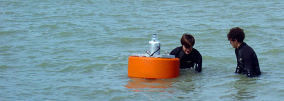
USGS researchers are trying to get a better sense of how hydrologic properties influence these pathogens and their transport patterns. Aiding in the research is a real-time monitoring network that includes nearshore NexSens MB-300 buoys with SDL500 submersible data loggers and cellular telemetry packages. Absolute level transducers are suspended beneath the Great Lakes buoys to measure information on wave energy.
With a fast enough sampling rate, these level transducers are capable of monitoring data about wave frequency and height. The sensor is mounted at a fixed location underwater and calculates the height of the water column above it. As a wave crest passes by, water column height increases; when troughs approach, it decreases. The resulting record of sea surface elevations can be used to calculate wave energy data.
The wave measurements will be combined with other real-time data, such as turbidity, as well as on-shore photosynthetically active radiation (PAR) and precipitation. This data will be analyzed along with routine water quality sampling at a number of beach sites.


0 comments