
On Pennsylvania’s flood-prone Fishing Creek, students to supply decision-aiding data
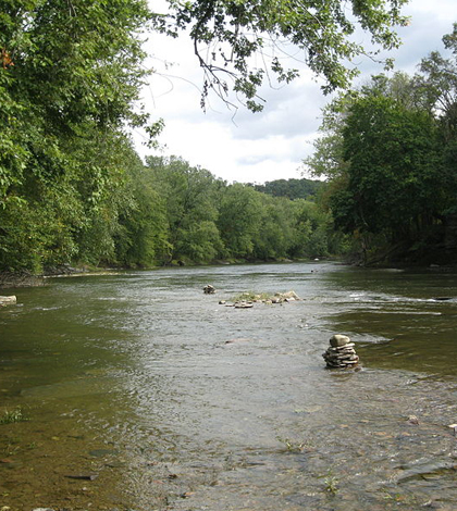
On a late summer day in 2011, Jen Whisner and a few of her students from Bloomsburg University of Pennsylvania floated down nearby Fishing Creek, logging the GPS coordinates of stream features like submerged trees, eroding banks and gravel bars.
They were on the lookout for “anything geomorphologically interesting,” said Whisner, assistant professor in the school’s Department of Environmental, Geographical, and Geological Sciences.
They didn’t know at the time that the data they collected would soon become the “before” picture–a reference point for a record-setting flood that would ravage the town of Bloomsburg, Pa.
“It was not intended to be a baseline for anything,” she said. “We were just looking around to see what we could see. And then as it happens, we had huge flood shortly thereafter.”
This flood came after Tropical Storm Lee parked over Pennsylvania and sent rivers to record highs that knocked houses off foundations. But it was only the most recent damaging flood to hit Bloomsburg, which sits at the confluence of Fishing Creek and the Susquehanna Rivers. The town has seen several major floods in the past century. The data is part of a growing initiative to involve Bloomsburg geology and geography students in tracking the changing creek, and the experience will teach students the skills of their chosen field while producing useful data to help regional planners cope with historically flood-prone waterways.
“We have a lot of students who are in geography and planning majors, so they would be the sorts of folks who go out and use these data,” Whisner said. “And the geology students would be the ones who go out and produce the data.”
The data that the students have produced includes survey data of a gravel bar within the creek that some residents wanted removed because they blamed it for pushing extra water above the banks during the flood.
To calculate how much water the bar could actually displace, Whisner headed to the site with some students and “clunky old technology” like a Jacobs staff, Abney level and a measuring tape. (“We just got a total station,” Whisner said. “So it’s very exciting.”) After determining the bar’s shape through surveying and its volume through Google Sketchup, Whisner said they figured the bar could displace around 4 to 6 inches of water along the creek’s north bank.
Managers ultimately removed a portion of the bar. But from a planning perspective, it’s not clear whether that’s a productive use of public funds. A dam was recently removed upstream of the bar, Whisner said. Even with a portion of the bar were removed, sediment that had built up behind the dam could eventually rebuild it.
“People too often react first and measure later,” she said. “They just sort of go with their gut about what’s a good idea and what’s an effective way to spend money. I think a little bit of science behind it is much better.”
By plugging students into the critical thinking behind good natural resources management, the school can help provide that science and a great educational experience.
“Especially in the fall. It’s usually nice, the water is warm, the water is low, they can wade and splash,” Whisner said. “Well, hopefully not splash too much. We don’t want the total stations wet.”
Image: Fishing Creek town of Bloomsburg and Montour Township in Columbia County, Penn. (Credit: Ruhrfisch, via Wikipedia Commons)


0 comments