
Q&A: Sanibel-Captiva buoy minders on new data for boaters, red tides
Between Florida red tides, fragile seagrass beds and pulses of nutrient-rich water from Lake Okeechobee into their coastal waters, the folks at the Sanibel-Captiva Conservation Foundation’s Marine Lab have no shortage of environmental issues to keep an eye on. They do just that with their RECON monitoring network that observes the estuarine and coastal waters around the group’s two namesake barrier islands in Southwest Florida.
They’ve recently added another data buoy to their array, this one equipped with a Nortek AWAC wave and current profiler. We caught up with the lab Director Eric Milbrandt and Research Assistant AJ Martignette who answered a few questions about the new addition.
Environmental Monitor: Where is the new buoy deployed?
Martignette: It’s three miles west of Pine Pass, which is the separation point between Sanibel and Captiva islands. We wanted to get it far enough off shore that we could get a good representation of the wind but not go far enough out that we had cell phone reception issues. Or that it took just hours to get out there to service it.
Milbrandt: The other part of the positioning is that offshore of the barrier islands are several fishing spots that are artificial reefs that were created by the county, the same funding source that provided the equipment for this project. It’s in direct line with all of these diving and fishing spots. We wanted for some of the guides and people who use those fishing spots to be able to look at the conditions before they go out there.
EM: How have the wave data looked so far?
Martignette: Fortunately — well, it turned out to be fortunate for us — we deployed it right before a weekend where we got 10-foot seas, which is a lot for us. So I was watching it all weekend to make sure the mooring didn’t break. We got a great amount of data showing the increasing waves.
Milbrandt: It’s endlessly fascinating, this stuff. You can look at it over and over again.

The AWAC wave and current profiler is housed within the “Barnacle” on the seafloor. (Credit: SCCF)
EM: Are there any plans to use the data for research as well?
Martignette: In the past we’ve had a big problem on our beaches with red drift algae — macroalgae that detaches from the bottom and washes up on the beach.
Milbrandt: Beaches in Lee County are economic engines. It’s a tremendous amount of economic benefit. People from all over the world come to visit, this is what they see: Big piles of rotting, stinking algae.
Martignette: We’ve had good anecdotal correlation of getting a storm and getting red drift algae on the beach, but we had no idea how strong the currents were at the bottom of the ocean.
Milbrandt: The working hypothesis is that depending on wave height, current direction, and the source of the material, we can better predict when and where the events are going to happen. And maybe have some kind of an effect on decreasing the sources of nutrients; It’s more for us a matter of understanding where it might land and predicting how long it will last.
EM: Any other research applications?
Milbrandt: Something that we didn’t touch on yet is this phenomenon called Florida red tide. It’s a microscopic algae that blooms in the water column and produces a toxin that causes respiratory irritation and significant injuries to mammals and sea turtles and air-breathing mammals. And people, when they’re on the beach.
Martignette: As far as the human impact, the waves tend to break up the cells and aerosolize the toxins. That’s how you can breath it in, and it’s like breathing in smoke. It chokes you up. The state University of south Florida has a model they use to predict two days out where they think the patch is going. We’re just offering up our data to them to help improve the model.
Milbrandt: We’re sharing data, the current data especially — to help the physical models that are predicting where the bloom is going to end up. With those kind of predictive capabilities, you could say, ‘Well, maybe this beach you could go to. But further south, this beach is a high respiratory irritation beach because of the physical conditions being dictated by the currents and the winds.’
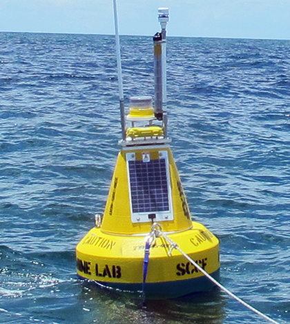
Top image: The buoy is deployed near artificial reefs popular with anglers and divers (Credit: SCCF)


0 comments