
Satellite instrument to bring new detail and frequency to U.S. air pollution data
NASA officials recently approved a project to build a space-based instrument that will pinpoint emissions with higher resolution than ever used in air pollution monitoring.
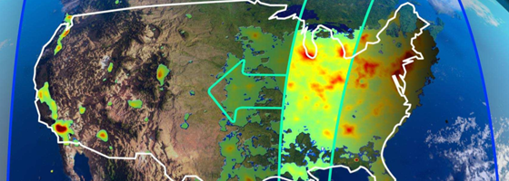
New technology will enable the instrument to scan hourly the North American Continent, from Canada’s tar sands to Mexico City. It will detect emissions in areas as small as nine square miles. What’s more, it can communicate on an hourly basis where most monitoring satellites communicate once a day.
It’s an advanced sensor thanks to years of research by science team members who had hands in five other spectrometers used for space-based air monitoring.
Scientists at the Smithsonian Astrophysical Observatory will lead the development of the instrument known as the Tropospheric Emissions: Monitoring of Pollution project.
Kelly Chance, TEMPO principal investigator and Smithsonian scientist, has more than 30 years of experience building space based monitoring equipment. “We were among a small group of people proposing an (air monitoring) satellite back in 1985,” Chance said of the Smithsonian Astrophysical Observatory.
") A spectrometer on TEMPO will have at least 30 times the resolution of other instruments Chance helped build and deploy into space.
A spectrometer on TEMPO will have at least 30 times the resolution of other instruments Chance helped build and deploy into space.
The TEMPO spectrometer detects pollutants by analyzing light. Different particles in the atmosphere cause a change in light waves reflected by Earth. TEMPO looks at 2,000 spectra containing various waves affected by atmospheric particles. It then looks at 2,000 points, north to south, on those spectra. Based on waves sensed, it determines which pollutants occupy Earth’s atmosphere and where they reside.
Detectable pollutants include ozone, nitrogen dioxide, sulfur dioxide, formaldehyde and aerosols.
TEMPO’s high resolution means any source of significant air pollution will be easily seen and identified within a manageable area, making polluters easier to spot. “The observations will help agencies to develop effective emissions control,” said Chance.
Regulators from the U.S. Environmental Protection Agency and the National Oceanic and Atmospheric Administration will have access to collected data.
TEMPO will be mounted on a high-orbit commercial satellite, like those used for cell phone communication. It will scan the continent from 22,000 miles above in geostationary orbit, which keeps it directly above North America.
The TEMPO instrument project was chosen from 14 competitive proposals. The science team will have a $90-million contract to create the instrument.
Scientists from the SAO, NASA Langley, Harvard, University of California Berkley, St. Louis University, University of Nebraska, and several other organizations will help design and create the instrument. Boulder, Colorado’s Ball Aerospace and Technologies Corp. will build the instrument.
The project has been fast-tracked with a delivery date set in 2017. Chance described the five-year development to production time as “very rapid.”
The science team members experience should streamline the process. Chance said many of the algorithms and sequences used for other instruments can be adapted to the TEMPO instrument.
“The next step is that we have to negotiate and put a contract in place,” Chance said.
Then scientists will begin to put their design elements together to create an instrument that will work with a satellite. “The biggest challenge is in learning how to combine our scientific instruments with a host satellite, implying constraints on vibration, instrument placement, available telemetry bandwidth, and launch schedule,” Chance said.
If all goes to plan, TEMPO will be part of a constellation of air monitoring instruments covering the North America, Asia and Europe. Space agencies in Asia and Europe will have instruments in space by 2018.
Image: An illustration of pollution-scanning path of the Tropospheric Emissions: Monitoring of Pollution instrument (Credit: TEMPO)


0 comments