
Study: Colorado irrigation canals support rare wetland habitat
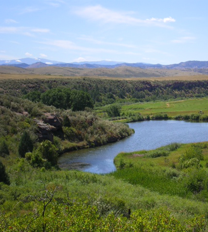
A wetland and pond in northern Colorado sustained by seepage from a nearby irrigation canal (Credit: Jeremey Sueltenfuss)
The extensive irrigation canals across Colorado that have made agriculture possible in the dry parts of the state have also disrupted natural hydrology, drying up natural aquatic habitats like floodplain wetlands.
But in a surprising twist, a recently published study shows that the irrigation canals that carry water away from rivers are also creating and sustaining functional wetlands in areas that wouldn’t otherwise support them.
“We’ve pretty much dried up a lot of our historic riparian wetlands (with irrigation), but what our research found was it created wetlands in places where you certainly wouldn’t expect wetlands to be,” said Jeremy Sueltenfuss, a wetland ecologist with the Colorado Natural Heritage Program and lead author of the study.
Documenting this connection is especially important in Colorado, where wetlands make up just 2 percent of the state’s landscape but support 90 percent of the state’s species at some point in their lifecycle. The findings could help ease conflicts between urban environmentalists and rural farmers over how much water ought to remain in the state’s streams or be diverted for irrigation.
Though the diversions are unpopular with conservationists, some are the sole water supply to wetlands that appear to be as old as the canals themselves.
“In the particular area we worked in, that goes back to 1890. So they’re over 100 years old,” Sueltenfuss said. “If you stopped running the water, those wetlands are dry.”
The irrigation has unintentionally supported wetlands through water that seeps out of canals through their earthen bottoms and sides. Irrigation companies keep close track of how much water they lose, but there hasn’t been much study on where it goes, Sueltenfuss said.
With the hypothesis that the water was leaking into and sustaining nearby wetlands, Sueltenfuss set out to identify wetlands within the service area of the North Poudre Irrigation Company where canals appeared to be a potential water source. Using GIS data and aerial imagery, he and his collaborators selected 20 wetlands where they would collect hydrologic data in an attempt to match wetland water table fluctuations with daily canal flows provided by the irrigation company.
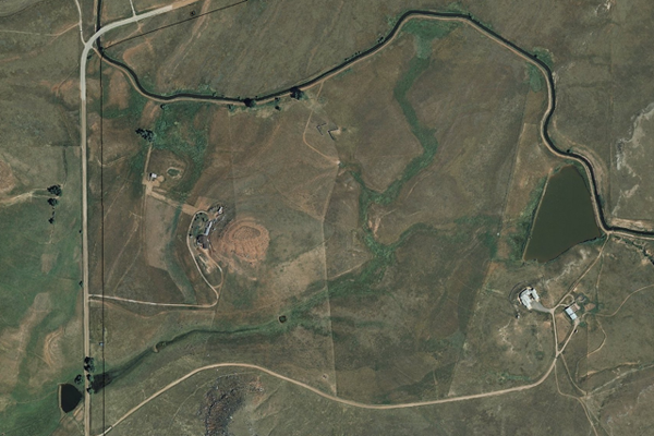
Seepage from an irrigation canal supports wetland vegetation growth seen in this aerial image (Courtesy Jeremy Sueltenfuss)
Across the 20 study sites, the researchers dug 70 1-meter monitoring wells where they measured water levels every two weeks from May to November. Six wetlands each had one well equipped with an In-Situ Rugged TROLL 100 water level logger that measured the water table hourly.
Wetlands fed by groundwater typically have stable water tables, Sueltenfuss said. But the water tables they measured showed clear fluctuations that correlated with the canal flow data. When the irrigation was flowing, the water table would rise near the surface and recharge the wetland. When irrigators stanched the flow, the table would drop.
“Matching up water table position over time with canal flow over time, you could see how they overlapped really nicely,” he said. “Much more clearly than I would have expected.”
The researches also conducted stable isotope analysis and found that the chemical signatures of the water of each wetland and its adjacent canal were generally identical.
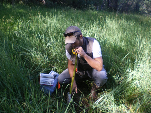
Researchers measured water levels in monitoring wells every two weeks (Credit: Jeremy Sueltenfuss)
The results of the study, published in the journal Wetlands, could lead to a new approach to wetland conservation in the state, Sueltenfuss said.
Urban environmentalists are often at odds with the agricultural sector, which they see as an outsized drain on the region’s scarce water supply that ought to leave more water in the rivers. But these findings suggest that there might be important overlap in the seemingly conflicting goals of agriculturalists and environmentalists, one seeking to conserve important aquatic habitats and the other to divert water for crops and cattle.
“The most exciting piece of it is this novel way to approach wetland conservation in terms of getting people from both cities and agriculture at the same table and having a conversation,” Sueltenfuss said.
Top image: A wetland and pond in northern Colorado sustained by seepage from a nearby irrigation canal (Credit: Jeremy Sueltenfuss)


0 comments