
Study: Groundwater use exceeds recharge in up to a third of major global aquifers
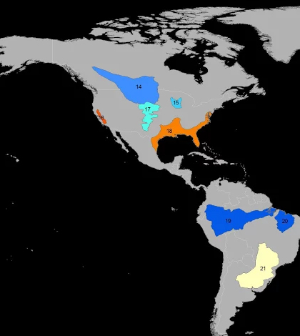
Researchers from UC Irvine used data from NASA’s GRACE satellite mission to show trends in groundwater storage. (Credit: UC Irvine/NASA)
Considering how long humans have relied on the Earth’s groundwater supplies for survival, industry and agriculture, we know relatively little about the processes that drain and replenish it.
More alarming still, scientists can’t agree on how much groundwater is left.
A pair of recently published studies used NASA satellite data to quantify groundwater stress, and highlighted major shortcomings in our understanding of the global groundwater supply. These studies are the first to use satellite data to determine groundwater loss.
Papers detailing the results of each study are available online in Water Resources Research.
One paper compared groundwater stress — defined by use versus availability — to replenishment rates in 37 major basins around the world. Dividing stress by refill rates, lead author Alexandra Richey developed a parameter she calls renewable groundwater stress framework.
That paper showed that up to a third of the world’s major aquifers are in distress, with groundwater use exceeding replenishment rates.
The second paper sought to determine the “lifespan” of those aquifers, comparing depletion rates to estimates of total storage. The greatest revelation from that study, Richey said, was that volume estimates vary wildly, and despite scientific advancement, “we don’t actually know how much groundwater there is.”
“Lakes and rivers and streams are pretty easy to monitor,” said Richey, who conducted the studies as a doctoral student at University of California, Irvine. “But groundwater is much harder to study, especially these large global aquifers that cover hundreds of thousands of miles in some cases.”
Very few of the basins included in the study had been the subject of previous efforts to determine total or remaining volume, Richey said. Those that had been examined often drew greatly disparate estimates from scientists, due to the wide range of models used for calculations.
Richey’s studies were unique in their use of data from NASA’s GRACE mission, two satellites that measure gravitational anomalies. Put simply, the satellites measure the difference between one another as they “chase each other around the Earth,” Richey said. As one satellite approaches a particular point of mass, such as a mountain range, it’s pulled closer to the planet, changing the difference between it and its partner.

Researchers from UC Irvine used data from NASA’s GRACE satellite mission to show trends in groundwater storage. (Credit: UC Irvine/NASA)
Water of all sorts, including surface water, snow, soil moisture and groundwater modify that mass, allowing the GRACE satellites to measure hydrological changes as well as morphological ones.
“The largest thing that causes Earth’s gravity to change on a monthly time scale is large movements of water stored on land,” Richey explained. “Because water is so heavy, we can convert these gravity anomalies into water anomalies.”
Richey and her co-authors used data from land surface models to subtract surface water, snow and soil moisture from the GRACE measurements, leaving a projection of groundwater changes from month to month.
Of course, even with other types of water removed, the satellite data offers little insight into the source of changes to water storage. Richey says she’d like to narrow her focus from 37 to just a few basins, examine the impacts of human usage on groundwater stress.
“I want to figure out how much of the water in these aquifers is being used specifically for agriculture, and then, within that, how we can change crop types or implement improved groundwater management strategies to more sustainably use groundwater,” she said.
In particular, South America’s Guarani aquifer interests Richey because of the large amount of data available on it.
While modern science is at a loss for comprehensive data regarding groundwater volumes, the causes behind depletion are pretty well known. Human population growth, agriculture, and naturally dry ecosystems are the primary drivers of depletion in most of the basins examined in the studies.
But for Richey, who is now beginning postdoctoral work at Washington State University, that knowledge alone just doesn’t hold water.
“The biggest thing that surprised me, and scares me, really, is that we don’t know how much groundwater there is,” Richey said. “As I dug into that, I found that our current base of knowledge on groundwater storage actually traces back to the 1960s and 1970s. They used really coarse assumptions and we’re still using those numbers today.
“That’s crazy, and we need to do better than that.”


0 comments