
Tagged seals and seabirds map Columbia River Estuary depth and salinity
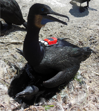
Nesting Brant's cormorant fitted with sensor tags to measure water conductivity, temperature, pressure (depth), and GPS location. Waterbird research was conducted under an Animal Care and Use Protocol approved by the Oregon State University Institutional Animal Care and Use Committee. (Credit: Anna Laws)
A study from the Columbia River Estuary suggests that sensor-toting seals and sea birds may be able to help map water bodies that research vessels don’t have the funds or agility to access.
In the spring and summer of 2013, researchers from Oregon State University and the state tagged 15 harbor seals and four Brandt’s cormorants with sensors that measured GPS coordinates, conductivity, temperature and depth. Over the course of two and half months, the sensors collected data as the animals moved around the estuary dived to the bottom to forage.
The study was a pilot project to see if data from animal-borne sensors could be useful in supplementing measurements from traditional oceanographic methods like ships and moorings, or if the data could stand on their own in areas where those methods are physically or financially not an option.
The data from the dives provided more than 100,000 profiles of temperature and conductivity that tracked the wedge of saltwater that periodically enters the estuary from the Pacific Ocean as tides converge with freshwater inputs.
“We were able to resolve the coming and going of the salinity intrusion in the channel of the estuary pretty well with the seals,” said Jim Lerczak, an associate professor in Oregon State’s College of Earth Ocean Atmospheric Sciences. “My bottom line is I’m cautiously optimistic that this data is useful.”

Harbor seal with attached GPS-phone tag (green and white) and CTD tag (orange).
This activity was conducted under NMFS Permit No. 13430-01. (Credit: Oregon Department of Fisheries and Wildlife).
Bryan Wright and Robin Brown of the state’s Department of Fisheries and Wildlife led the seal tagging effort. Don Lyons and Dan Roby of the Oregon State University Department of Fisheries and Wildlife are conducting the cormorant tagging, which is ongoing.
In addition to mapping the estuary’s salinity, the researchers were interested in learning whether the georeferenced depth measurements captured during the dives could be used to build a bathymetric map of the estuary. Lerczak said the profiles of the seal and cormorant dives that go all the way to the bottom are distinctive from those that stop halfway and return to the surface.
“The profile of the dive, based on the seal and cormorant’s behavior, looks different when they go to the bottom as opposed to just mid-depth,” he said. “That tells us that this is a good dive to assess the depth of the water.”

Five dive profiles for a tagged cormorant show one partial dive and four to the sea floor, determined as those for which the animal spends a significant time at the maximum depth. (Credit: Jim Lerczak)
The animals were especially useful for mapping areas of the estuary like intertidal sand bars where the seals haul out but boats can’t access. But while the seals provided bathymetric data for those areas, much of the rest of the estuary went without survey. Both bathymetric and salinity-mapping applications were limited by the fact that the seals go where the seals want to go.
Even so, the benefits are clear. The sensors and tagging operations are relatively inexpensive compared with the cost of keeping a research vessel on the water. The sensors also have the potential to collect data for years, while a ship-based expedition typically lasts only weeks or months.
Lerczak and his collaborators are continuing to tag cormorants, which had a limited role in this study. They’ve also applied for funding to move the research out to the coastal ocean, which might prove to be a more stable research setting than the estuary.
“Every tide, every hour, things are different in the estuary, and so the hope is that in the coastal ocean we can be in an environment where things change over the period of a day or so,” he said. “It’s a little easier to get robust statistical information about what’s going on in the water column.”


0 comments