
Estuaries: A balancing act
Throughout human history, people have always wanted to be where the rivers meet the sea. The mix of freshwater and saltwater species surrounded by a variety of terrestrial environments makes estuaries hubs of rich biodiversity.
However, if a change in any of the contributing environments occurs, the delicate balance of the area can be thrown off, affecting thousands of species that depend on these brackish waters. Catfish, shrimp, crabs, oysters and clams, among other species, all depend on healthy estuaries. The National Estuarine Research Reserve System (NERRS) is working to maintain these areas so that community members can continue to enjoy them while gaining a deeper understanding of delicate estuary ecosystems.
The National Oceanic and Atmospheric Administration (NOAA) has teamed up with the 22 coastal states that participate in NERRS. Founded in 1972, NERRS is a network of reserve sites that promote stewardship, education and preservation of estuaries. NOAA ensures funding and standardizes equipment and management practices, said Ralph Garono, the reserve manager for the Lake Superior Reserve in Superior, Wis. The 28 research reserves are managed daily by local agencies and organizations that receive funding and direction from NOAA. Each reserve is accessible to community members and those who may wish to use estuaries as education resources. The estuaries also function as a living laboratory for researchers.
Standard real-time monitoring probes in each reserve transmit data every 15 to 30 minutes, which is then made available online. Most reserves also take monthly grab samples to evaluate biochemical oxygen demand, nitrate and nitrite concentrations, and bacteria. The Centralized Data Management Office (CDMO) aggregates data from all the reserves and provides quality assurance and control. This centralized control ensures that all data is collected and distributed uniformly throughout NERRS. The CDMO synthesizes data into reports that can be viewed on the NERRS website.
Each NERRS reserve uses a three-pronged System-Wide Monitoring Program (SWMP) to determine how human and natural events affect estuary ecosystems. The program surveys short-term fluctuations in water quality, biological populations, and watershed and habitat health. The water-quality focus includes abiotic conditions such as dissolved oxygen, pH, sediments, organic contaminants, and tidal range. Because estuaries are at the intersection of two bodies of water, measuring and monitoring them can be complicated.
“Nutrients may come in [to the estuary] in one form and transition into a completely different form that may not be available for organisms,” Garono said.
The second prong, biological monitoring, surveys species in the area as well as invasive and rare organisms that could be bio-indicators of a change in the environment. Researchers also look at population characteristics and habitats. Landscape is the third focus. This includes a look at how the watershed and coastal area is changing over time and how the land is being used.
According to NERRS, SWMP is a key component of the new Integrated Ocean Observing System, an information source that provides oceanic and coastal data for environmental protection purposes and some industrial uses. Data collected from NERRS reserves is used for weather forecasts, and by fisheries and transportation services.
The NERRS program also provides education and employment opportunities for the local communities it serves. Through its Graduate Research Fellowship Program, reserves hire graduate students to monitor the coastal areas while gaining valuable experience in their field of study. NERRS attracts high-quality researchers by providing a stipend as well as state-of-the-art equipment. Local schools often utilize the data to teach students about estuaries and environmental stewardship. Public outreach is also available through adult estuary training and materials that are provided to city councils and coastal planners.
“The purpose is not only to do the research but make sure it gets transferred to different user groups,” Garono said.
The information is pertinent to coastal areas where many community members come to live simply because of the view from a shoreside home. Many are not aware of the delicate ecosystem in their backyards and how their activities can contribute to the long-term health of the estuary. NERRS data reflects the changes that may be caused by the abundance of human activity in the fragile coastal areas.
“We must forge science in people’s minds so they understand the consequences of their actions,” Garono said.
Project Overview
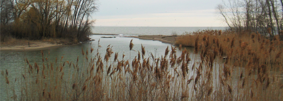
Old Woman Creek State Nature Preserve and National Estuarine Research Reserve is one of the few remaining relatively natural freshwater estuaries in the Great Lakes region. On the south-central shore of Lake Erie, Old Woman Creek and lake water mix to form a unique ecosystem.
The 571-acre preserve provides critical habitat for native species and migrating birds and offers a unique opportunity to research the ecological benefits provided by these fragile estuarine systems.
To assist in the understanding and preservation of the estuary, an automated water monitoring system was installed at Old Woman Creek Nature Preserve. The system is part of a long-term data set collected at National Estuarine Research Reserves around the country.
System Description
Two water quality monitoring stations were deployed: one where Old Woman Creek enters the preserve and another near the mouth of the estuary. At both stations, NexSens radio data loggers and multi-parameter sondes with temperature, conductivity, salinity, dissolved oxygen, pH, depth, and turbidity sensors were installed.
At each site, water quality and hydrology data is collected and transmitted via license-free spread spectrum radio to a base receiver located at the Old Woman Creek visitor center. A computer connects to the radio receiver, and uploads data to an online datacenter at WQData.com. This data is used in environmental education as well as restoration and resource management decisions.


0 comments