
Turner C-FINS fluorescence monitoring and mapping system designed by users
Prototypes rarely make it to production unchanged, but the Turner Designs C-ray C3 fluorometer body went straight from garage prototype to production.
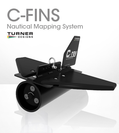
It is incorporated into the Turner Designs C-FINS system, which spawned out of the need for a towable fluorometer that could be used during oil spill responses.
The C-FINS, or Fluorometric Integrated Nautical Mapping System, allows users to combine any three Turner Designs Cyclops Fluorometers in a towable finned body based around the C3 monitoring system.
It integrates global positioning system coordinates from an external GPS with RS232 connectability into samples measurements. Users can map algal blooms with a chlorophyll A fluorometer, or study an oil sheen with the Turner Designs crude oil sensor.
Development started with an experiment on the Turner Designs C3 fluorometer in Alaska in 2007. Brian Parscal, owner of Parscal Pacific, tested the C3 during an oil spill response exercise. “One of the first things we discovered was that when you put it in the water it floated,” he said.
The instrument was not designed to tow, but did provide quality data during the test.
Parscal built a prototype body for the C3 to remedy the issue. During a weekend in his garage he made a body out of steel and PVC tubing. He added fins to make it glide beneath the water’s surface.
Parscal took the fluorometer out for a second test run. The C-ray body worked the first time, causing the fluorometer to cruise beneath the surface with ease at low speeds. “As you tow it, the hydrodynamics will actually pull it down,” he said.
Tom Brumett, sales engineer with Turner Designs, said the quick innovation created an out-of-the-box solution for researchers who want to collect data in a wide swath of open water.
Turner Designs tapped into another customer’s application to add in GPS parsing. Paul Barter, a senior marine scientist with the New Zealand-based Cawthron Institute, used the Turner Designs 10AU fluorometer in combination with ArcGIS to map chlorophyll A in a mussel farm. He details his experience in Turner’s 2004 January Newsletter.
Barter helped Turner Design engineers give the same capability to the C-FINS package. The company provides free software that allows the C3 to communicate with a GPS and ArcGIS Software.
Brumett said the goal of the monitoring package is to keep researchers focused on their studies and not on equipment integration. “As a researcher, the last thing you want to do is spend a lot of time and resources messing with software code,” he said.
Users simply hook the C-FINS system up to a laptop, attach a tow line, set a sampling interval and start recording data.
Parscal said there were seven C-FINS systems deployed during the Deepwater Horizon Oil Spill. He worked with the U.S. Coast Guard, using the fluorometer systems to evaluate the effects of dispersants on oil sheens.
When it comes to applications, Parscal said users may have to try a few different tow cable configurations to get the fluorometer cruising through the water to their satisfaction. “Don’t be afraid to experiment,” he said.
Recommended towing speed for the fluorometer is 4 knots in shallow water one meter deep or less. As water deepens past 10 meters, recommended towing speeds progressively slow to around 1 knot.
Once cruising, the fluorometers sample at a fixed time interval. Data can be viewed in real time. The C3 fluorometer will collect up to 480,000 data points.
Turner Cyclops sensors available for integration into the C-FINS package include: tryptophan, crude oil, PTSA Dye, refined fuels, chlorophyll, turbidity, fluorescein, Rhodamine, blue-green algae, optical brighteners and CDOM. Custom optics are also available.


0 comments