
USGS: 2011 streamflow set record lows in South, record highs in North
A U.S. Geological Survey analysis of the the 2011 water year (Oct. 1, 2010 to Sept. 30, 2011) shows divergent streamflow trends across the country, according to a recent report from the agency.
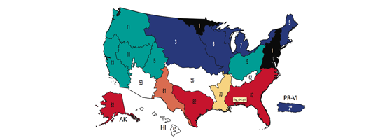
The study (PDF) is based on data from the agency’s network of more than 10,000 stream gauges. Compared with data collected from 1930 to 2011, the 2011 water year ranked as the 16th wettest nationwide. However, streamflow varied widely from region to region.
Montana, North Dakota, South Dakota, Minnesota, New York and Vermont experienced record-high levels of streamflow in 2011. Meanwhile, Texas and Alaska had record lows and Louisiana, Florida, Georgia and South Carolina were much below normal.
Image: 2011 streamflow levels by USGS water resource area. Black and blue are above average, red and yellow are below. (Credit: USGS)


0 comments