
Wave buoy off Majuro Atoll to keep islanders aware of unsafe seas
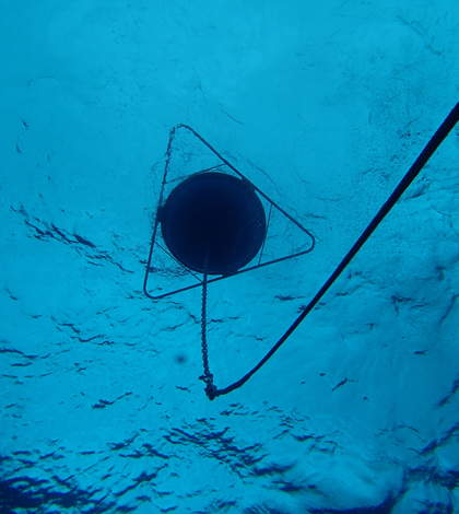
A view from below of the wave buoy bobbing off the coast of Hawaii’s Majuro Atoll (Credit: PacIOOS)
Data from a new wave buoy deployed off the Marshall Islands’ Majuro Atoll is helping to keep islanders safe from high ocean swells. It also alerts fishermen to when they need to stay off the water.
Wave forecasting is particularly difficult in the region, and researchers at the Pacific Islands Ocean Observing System say the new buoy, named “Kalo,” will also help them to inform safe transit and recreation near the atoll. The buoy was deployed in July and is transmitting data on wave height, wave direction, wave period and sea temperature through satellite telemetry.
“‘Kalo’ is the name of a Marshallese bird that flies only near land,” explained Kimball Millikan, Marine Research Engineer with PacIOOS at the University of Hawaii. “Whenever a sailor sees a kalo, the sailor automatically knows that land is near.”
The buoy’s location not too far from shore was chosen so that it could focus on the movement of waves traveling from the north, south and east. It was deployed with help from islanders after acoustic survey equipment made sure that its anchor would reach a secure hold.

The crew deployed the wave buoy on a steep, sloping seabed (Credit: Karl Fellenus)
Deploying a buoy near Majuro has its challenges due to the steep, sloping seabed, says Millikan. “But as our small vessel coughed and sputtered to our (deployment) destination, the Marshallese crew chewed their betel nut with a smile and were always eager to help with prep,” said Millikan.
In addition to providing critical safety data for the atoll and its residents, the buoy’s data will be used by weather forecasters and researchers working to develop flood forecasts for Majuro. It joins 11 other buoys in the PacIOOS network that monitor conditions in the Pacific Islands.
“All the buoys (in the network) are tethered to the bottom with an acoustic release,” said Millikan. “This allows recovery of the complete mooring line if cut by pelagic fish, debris, entanglement or fishermen’s lines and hooks.”

A crew of local islanders helped deploy the wave buoy (Credit: Greg Zega)
Top image: A view from below of the wave buoy bobbing off the coast of Hawaii’s Majuro Atoll (Credit: Karl Fellenus)


0 comments