
Boulder Creek Critical Zone Observatory captures Front Range flood data
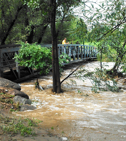
Boulder Creek floods on Sept. 13 (Credit: Nate Rock)
On Sept. 10 in the Front Range of the Rocky Mountains in Northern Colorado, water moved through Gordon Gulch at something like a trickle before flowing into North Boulder Creek. By midnight on the 13th, the water level had jumped nearly two feet.
The stream would eventually rise even higher, but that midnight measurement was the last recorded by a stream gauge that gave way to a rushing torrent that would contribute to catastrophic floods across Front Range communities.
Up until the record rainfall ripped the gauge from its fastenings, the instrument was part of a intensive long-term monitoring effort in the area operated by the Boulder Creek Critical Zone Observatory. Data from the University of Colorado-based observatory’s meteorological, soil and stream sensors, as well as their manual sampling efforts, have already contributed to an early view of the magnitude of the event. Ongoing analysis of their samples will profile the chemical content of the floodwaters.
The Boulder Creek Critical Zone Observatory is one of six CZOs across the country that focuses on the planetary layer from the bedrock to the top of the tree canopy. The Boulder Creek CZO has a particular emphasis on the effects of erosion and weathering on near-surface structure. It turns out the tools for studying those processes are well suited for capturing the effects of a thousand-year storm.
Observatory scientists have instrumented three sub-basins across the Boulder Creek watershed. That includes continuous data from meteorological stations measuring precipitation; soil pits with sensors for temperature, moisture and water potential; groundwater wells measuring depth to water table; stream gauges; and event-based autosamplers that begin filling bottles when water levels reach a certain height.
One autosampler had only recently been installed before warm air from the south ran into a cold front parked over Colorado, setting up sustained precipitation that dumped more rain on Boulder in a week than it saw throughout all of 2012.
“It captured two days of the storm, which is awesome,” said Nate Rock, the observatory’s field manager and professional research associate. “I was very happy to show up and see that my $6,000 tool was still there, and it was full of interesting samples.”
")
Gordon Gulch site after flood waters receded. The loose stream gauge backed up flood debris under a foot bridge. (Credit: Nate Rock)
So far the samples have shown an unexpected spike in aluminum, Rock said, though much of the chemical analysis is still ahead of them.
The rainfall shattered records at the station’s meteorological towers. That’s not surprising, as their records go back five years and the storm set new highs in 1-day, 2-day, 7-day and monthly totals for datasets going as far back as 1893.
The groundwater wells showed that the water table rose to a level similar to what they see during spring snowmelt. One well rose two meters above the typical snowmelt peak.
“Normally that’s our exciting time of the year,” Rock said of the snowmelt pulse in April or May that typically fades to baseline over the summer. “But we actually had a fairly significant summer event in July and then this fall was obviously like nothing we had ever seen before.”
Though the rainfall levels sometimes exceeded levels likely to occur once in a thousand years, the rising waters never achieved the “thousand-year flood” that some media outlets reported. The water rose between the 50- and 100-year flood markers on a downtown memorial to geographer Gilbert F. White, Rock said.
“A thousand-year flood would have put that thing 15 feet under water.”
")
The flood pulled this guardrail out of the ground and strung it across Boulder Creek (Credit: Clayton Jensen)
The event has generated a lot of interest among scientists, Rock said. The annual meeting of the Geological Society of America in October happened to fall in Denver this year. In a late-game addition to the proceedings, the observatory crew led a field trip of 70 geologists through their field sites and talked about the floods. Meanwhile, life is returning to normal for many around the city of Boulder, though some are still grabbling with washed-out bridges and significant property loss.
“We would never wish this on our friends and neighbors,” Rock said. “But it provides a unique opportunity to better understand the world we live in.”
Top image: Boulder Creek floods on Sept. 13 (Credit: Nate Rock)


0 comments