
Iowa researchers find Atlantic hurricanes often contribute to Midwest floods
With its expansive network of stream gauges, the U.S. Geological Survey has captured data relating to post-hurricane surges along the Atlantic Coast for years. But, as a new study points out, gauges deep in the Midwest have charted flooding that sometimes comes after the great open-ocean storms.
Led by researchers at the University of Iowa, scientists gathered as many data sets as they could find on Atlantic storms taking place within 100 kilometers of the Eastern Seaboard. They say their findings address a long-existing knowledge gap in understanding the full effects of Atlantic hurricanes on the country. Their work will also help inform predictions of economic damage following tropical storms in the future.
For the study period, which looked at 1981 through 2011, investigators gathered data from more than 3,000 USGS stream gauge stations located around the Midwest, an area that roughly falls between the Appalachians and the Rocky Mountains.
“The idea is that we’re here in Iowa, the soul of central America,” said Gabriele Villarini, assistant professor of civil and environmental engineering at the University of Iowa, while explaining the study’s focus area. “It’s defined by the U.S. census, but I like to say that if you tell me which state, I can tell you if it’s in the Midwest.”
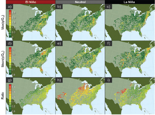
Dependence of tropical cyclone flood number and magnitude. (Credit: Villarini, et al.)
The area, he goes on to say, is not left unscathed in the days following Atlantic storms. The tropical cyclones, which many see as circular in structure, change in distribution as they make landfall.
“They undergo an extratropical transition, and they no longer have a nice circular structure,” said Villarini. “But the rainbands can stretch three to four hundred miles from a storm.”
And its those subsequent storm patterns that often bring flooding to the Midwest. Areas along the east coast, like the Carolinas, Florida and Maine see quite a bit of floods too, says Villarini. “One of the things that we clearly got is that the eastern U.S. is subject to flooding from tropical cyclones,” said Villarini. “The Central and Midwest U.S. also, reaching Chicago or even Detroit.”
It’s difficult to tell which areas are more vulnerable to flooding caused by tropical cyclones, says Villarini. But the research did measure economic impacts of flooding caused by tropical cyclones.
“We would have expected the East and Gulf Coasts would be more likely to see flooding, as well as far inland as we saw them,” said Villarini. “If we can raise awareness about this kind of hazard, then we can provide a stepping stone for subsequent work on the economic impacts of these events.”
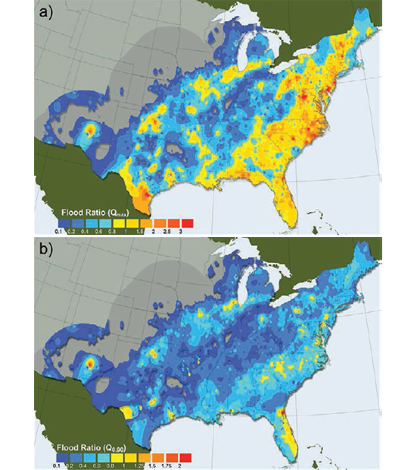
Top image: Maximum (a) and 90th percentile (b) flood ratio values associated with tropical cyclones at each location. (Credit: Villarini, et al.)


0 comments