
National Parks water monitoring puts sondes through their paces
As a hydrologist responsible for tracking water quality data in 22 National Parks across the southeastern U.S., Joe Meiman covers a lot of ground.
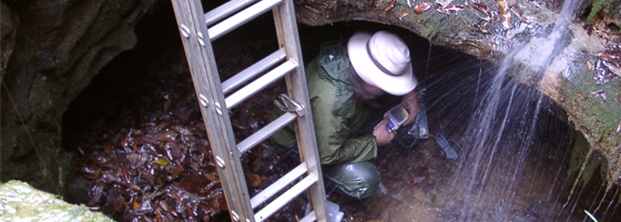
So does his equipment. Meiman has deployed data-collecting sondes in the clear, freshwater streams of the Cumberland Gap National Historical Park while the instruments were still covered in anti-biofouling paint meant to fend off barnacles in marine waters of parks along the Gulf Coast.
“They were the same data sondes that I’ve used in the hypersaline environments that are now in a low ionic environment of a mountain stream,” Meiman said. “It’s about as extreme as you’re going to get, as far as one end of the continuum to the next.”
The instruments are decontaminated between stints in different ecosystems to keep invasive species from hitchhiking.
Meiman works under the National Parks Service’s Inventory and Monitoring Program, which divides 270 parks across the country into 32 networks that share similar natural resources and geographic characteristics. Breaking parks into groups helps streamline monitoring by focusing attributes that are broadly applicable to all the parks in a network, making data easier to share and economical to collect.
“It’s basically to select a few very fundamental natural resource measurements that will provide park managers with basic information that they need to make informed decisions,” Meiman said.
Each network goes through a rigorous process to select which fundamental measurements, called vital signs, are the most to applicable to all of its parks. For example, one vital sign in the Great Lakes Network is persistent contaminants like PCBs, DDT and PBDEs. One of the Upper Columbia Basin Network’s vital signs is sagebrush steppe vegetation.
All 32 network across the country have a vital sign with a water quality component.
“Water quality is one that spans from the Virgin Islands up to the Gates of the Arctic in Alaska,” Meiman said. “Everyone is looking at that.”
Meiman works in the the Cumberland Piedmont and Gulf Coast networks, which include 22 parks from Brownsville, Texas to Greensboro, North Carolina.
Meiman is based in Mammoth Cave, Ky., but within a recent span of weeks he was retrieving sondes from the Cumberland Gap in Kentucky, collecting grab samples along the Natchez Trace Parkway that runs 440 miles through Tennessee and Mississippi, and picking up a few more sondes from Gulf Islands National Seashore in Florida.
Also within Meiman’s jurisdiction is the Padre Island National Seashore along the Gulf Coast of Texas. Padre Island is the world’s longest barrier island, and it lies between the Gulf of Mexico and Laguna Madre, a long, skinny, shallow water body where the Park Service collects continuous water quality data with YSI sondes. Laguna Madre is largely cut off from the Gulf and receives very little freshwater from mainland streams. That isolation, paired with high evaporation, results in salinity levels that are around 50 percent higher than ocean water.
The warm water and high salinity is a boon for barnacles. The high salinity and the abundant barnacles add up to what Meiman said might be the most intense biofouling environment in the country. Barnacled sensors need to be swapped out for clean ones every two weeks.
The barnacles also thrive on the high levels of dissolved oxygen driven by the respiration of the seagrass beds. Daytime oxygen saturation can go as high as 200 percent in the summer. That’s quite a sight for someone who was a hydrologist for the Mammoth Cave National Park for 15 years before chasing data across 22 parks.
“It looks like the water is effervescent in places with all the oxygen coming off the seagrasses,” he said. “The bulk of my work for the (National Park) Service has been working in caves, and this was as different as I can imagine.”
Image credit: National Park Service


0 comments