
NOAA fleet sets sail on 2014 hydrographic survey season
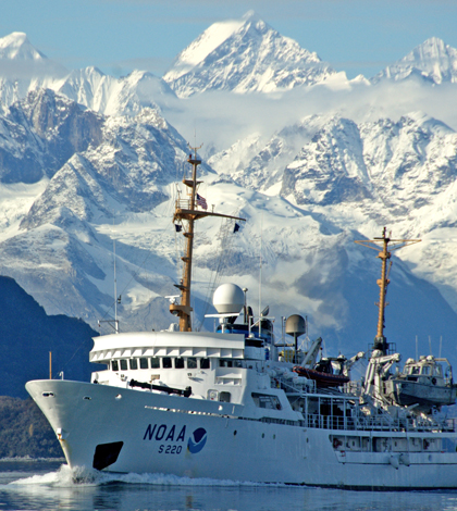
The NOAA Ship Fairweather in front of its namesake Mt. Fairweather in southeast Alaska (Credit: NOAA)
Continuing a centuries-spanning monitoring operation, the National Oceanic and Atmospheric Administration’s 2014 hydrographic survey season kicked off late last month. A fleet of NOAA ships and boats will survey more than 2,000 square nautical miles of U.S. coastal waters to gather an array of aquatic data.
The survey is conducted annually through NOAA’s Office of Coast Survey, the federal government’s first scientific agency. Under recommendation of President Thomas Jefferson, Congress passed legislation requiring a survey of the East Coast in 1807, and depth-measuring vessels began their work in the mid-1800s.
“The history of the Coast Survey goes back to the beginning of the United States, to a time when there were only 15 states, all clustered on America’s East Coast,” said Dawn Forsythe, communications specialist at the Office of Coast Survey. “Nearly all commerce between the states was by coastal shipping… and all foreign trade, especially critical to our new nation, had to come by ship.
“With so many ships coming into our ports and harbors, shipwrecks were common, and it was clear that accurate nautical charts were needed,” Forsythe said.
Today, NOAA vessels still measure water depths and study the ocean floor to help update nautical charts. Areas of focus for the 2014 season include Alaska’s Kodiak Island, an area for which depth measurements are sparse and outdated, and the Rhode Island Sound, where the NOAA ships Thomas Jefferson and Ferdinand Hassler will help establish a safe route for deep-draft oil tankers. Many other coastal regions are included in the survey, from San Francisco to Chesapeake Bay.
Although the surveys’ locations change year by year, the methodology and type of work is fairly consistent every season, according to Jeffrey Ferguson, chief of the NOAA Hydrographic Surveys Division. Several projects, including those at Rhode Island Sound and Kodiak Island, are continuing from previous years.
“The Thomas Jefferson project, for example, in Long Island Sound, is the culmination of several years of work to complete a modern survey of the entire Sound which will continue into Rhode Island Sound,” Ferguson said.

NOAA Ship Thomas Jefferson in New York Harbor in 2004 (Credit: NOAA)
In the past, extreme weather events have necessitated recovery efforts during survey season.
“The survey response after Post-Tropical Cyclone Sandy was quite intensive,” Forsythe said. “Helping to re-open ports after hurricanes is always fast-paced, as we work with ports and the Coast Guard to resume maritime commerce.”
During that project, the Thomas Jefferson surveyed through the night after Sandy struck to chart safe lanes for fuel deliveries into New York Harbor.
Data gathered by the surveys are used in additional applications, such as siting wind farms, mapping ocean habitats and helping state government with ocean projects. The Office of Coast Survey currently employs four NOAA ships and six 28-foot survey boats known as “navigation response teams,” Forsythe said.
Private entities also contribute to the surveying efforts.
“Coast Survey has had a very successful contracting program since 1998,” Ferguson said. “In Fiscal Year 2014, we received $25 million in appropriations for our contracting program… Our contracting partners have conducted surveys in all parts of the nation over the years.”
The Office of Coast Survey underwent minor operational reductions in 2013 due to sequestration and other budget issues, Ferguson said, but funding has since returned to normal.
“The level of effort of the hydrographic ships has also rebounded from the previous year and we expect a productive 2014 field season,” Ferguson said.
Top image: The NOAA Ship Fairweather in front of its namesake Mt. Fairweather in southeast Alaska (Credit: NOAA)


0 comments