
Optical sensors shed new light on sediment near the seabed
When a month-long oceanographic mission on the Atlantic seabed ends with a 11-foot steel tripod capsizing and destroying part of its multi-thousand-dollar sensor payload, you might expect that to dampen the researchers’ spirits.
Apparently, at least some oceanographers are optimists.
“From a technical point of view, it was a very successful experiment,” said Chris Sherwood, an investigator on the tripod project and a research oceanographer with the U.S. Geological Survey’s Woods Hole Coastal and Marine Science Center.
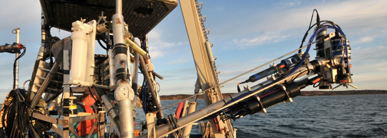
Before it tipped, the custom-built tripod spent most of October 2011 sitting under 40 feet of water around a mile offshore from Martha’s Vineyard. The structure was loaded with instruments to measure the effect of currents and waves on sediment and other suspended material near the seabed. Several sensors were mounted on an arm that extended 8 feet from the rig. A motor slowly swung the arm in an 8-foot vertical arc, allowing the devices to capture how particle composition and behavior changed along with depth.
A report on the mission, instruments and results was recently published online.
Though carried out by the USGS, the study was partially funded by the U.S. Navy’s Office of Naval Research. Despite the military backing, the work will have clear contributions to civilian life, including the development of numerical models that can help predict sediment-related events like shoal formation, movement of contaminated sediments and filling of dredged shipping channels.
The Navy also has a stake in sediment behavior. For example, they’d like to be able to predict underwater visibility at a particular location without having to be there to take measurements.
“They’d like to be able to remotely predict whether or not, say, their SEAL team is going to be able to see anything or not,” Sherwood said.
The project is one of many under the Navy’s Optics, Acoustics, and Stress In Situ project, a major component of which is exploring the relationship between data generated by acoustic and optical instruments. Several sensors of both varieties were installed on the tripod.
Acoustic instruments, which generate measurements by bouncing sound waves off suspended material, are well-established and very effective in the ocean, where sound can travel great distances. However, acoustic instruments can’t deliver very detailed information about the individual particles themselves. Optical instruments, on the other hand, operate by bouncing light off particles. Though light doesn’t travel through the ocean as well as sound, its short wavelength allows optical tools to generate high-resolution information on suspended particles.
Where acoustic instruments can tell how much material is suspended in the water, optical instruments can tell whether a single particle is a grain of sand or colony of phytoplankton.
“It’s much easier to make an optical picture of a small particle than it is an acoustic picture of a small particle,” Sherwood said. “In acoustics, you basically get a much fuzzier return because you’re working with a much coarser wavelength.”
Some of the most interesting particle-level optical data came from a submersible holographic camera from Sequoia Scientific, Inc. The camera, which cost around $35,000 and is one of the first of its kind available commercially, captured discernible images of phytoplankton on the scale of tens of micrometers.
The camera also produced a lot of data, capturing 2-megabyte image every 30 seconds. The large files and extra power needed to move the instrument-bearing arm up and down meant that the tripod couldn’t operate on battery power and data loggers alone. The project made use of the Martha’s Vineyard Coastal Observatory operated by Woods Hole Oceanographic Institution. Underwater cables running from the tripod to the observatory provided power and an Internet connection.
In addition to the power and Internet hookups, the location is ideal for this type of study because the region often catches a glancing blow from a hurricane in the fall. For scientists interested in the effects of wave action on sediment, that’s a good thing. A rollicking storm makes for great data.
That’s also one of the reasons that the nor’easter that blew in and crippled the tripod didn’t spoil the experiment, Sherwood said. That, and the scheduled mission had already ended.
“The mission was already over, although the data right at the very end is great storm data, even though it tipped over,” he said.
And, while instruments come and go, data is forever.
“We broke a couple of instruments, but we got all the data back, which is always key,” he said. “There’s certain instrument attrition that we have to factor into this anyway.”
Image: Tripod-mounted optical imaging instruments before being deployed to the seabed (Credit: USGS)


0 comments