
Study On Middle Toklat River Considers Which Flow Regimes Dominate
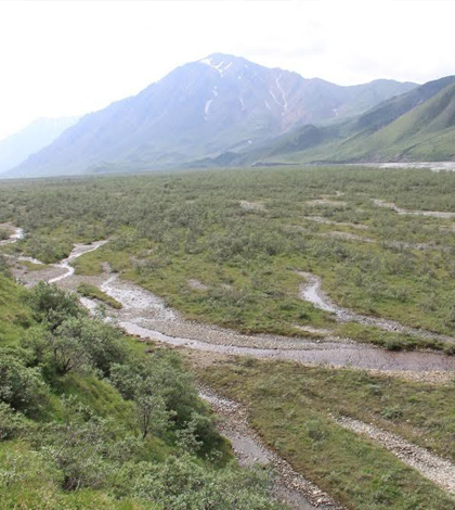
Site on the Middle Fork Toklat River where the investigation took place. (Credit: Michael Grocott)
Thanks in part to its secluded location, the hydrological dynamics of the Middle Fork Toklat River in Alaska’s Denali National Park have been somewhat understudied. But one researcher from the University of Birmingham is looking to change that, at least for a small floodplain terrace there.
Michael Grocott, a doctoral researcher in the university’s School of Geography, Earth and Environmental Sciences, spent more than three months in 2014 monitoring groundwater level responses across the terrace. He used piezometers along with Solinst barometric pressure and water level loggers in the work, the results of which are soon to be peer-reviewed and published.
The loggers have helped Grocott to measure groundwater response across the terrace, as well as to track the stage of groundwater-fed streams running through it. From there, he has worked to establish discharge based on calculations involving the relationship between it and stage. Finding that information is important because no other researcher has done it before, but also due to the stream’s location near a glacier in the park.
“Groundwater-fed streams that occur on the floodplains of glacial river systems are important biodiversity hotspots. They support greater taxonomic abundance and richness amongst aquatic macroinvertebrate assemblages compared to the main glacial river channels,” said Grocott. “Understanding the hydrological dynamics of these stream systems (groundwater behavior and stream response) is necessary so that we can establish the implications of climate change upon them.”
Some of the changes that are anticipated in the future, and which could impact this part of the Toklat River, include many things that could change the water balance. Grocott names off a few examples, including glacial retreat, melting permafrost and declining winter snowpack. They may also have to contend with earlier spring melts and shifts in summer precipitation patterns.
“Determining the key water sources and flow paths is integral to understanding the impacts of these changes on their long-term stability,” said Grocott.
Grocott says that water pressure was the key measurement in the work. It was used to inform calculations of streamflow outputs. But the whole picture of the water balance, including groundwater inputs, was captured.
The data will serve as a first-order attempt, Grocott says, to characterize water’s movement on the terrace and its relationship to groundwater-fed streams. He has a few results to share before academic review and publication.
“This water balance work has established that these groundwater-fed streams, on the margins of glacial floodplains, are potentially dominated by flow from adjacent hillslopes rather than upstream meltwater,” said Grocott. “Estimated stream outflow was dwarfed by the potential input of summer precipitation and winter snow accumulation on the hillslopes above.”
Top image: Site on the Middle Fork Toklat River where the investigation took place. (Credit: Michael Grocott)


0 comments