
Teachers a vessel for oceanic science through NOAA program
For a simple definition of hydrographic surveying, just ask the sixth graders at Northland Preparatory Academy in Flagstaff, Ariz. Kaci Heins, 29, their science and social studies teacher, instructed the first part of the semester aboard NOAA Ship Rainier. Heins cruised the Alaskan coastline from September 17 to October 7 as part of a survey mission.

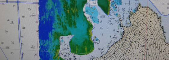
Through her Teacher at Sea blog she kept while on Rainier, Heins communicated with her sixth graders the importance of hydrographic surveying. This is the use of sonar to make a three-dimensional map of the physical sea floor and the littoral land areas around it. Data collected during one cruise takes about two years to show up on nautical charts, which are used to plot navigational courses for ships. The data is also used by fisheries to map different species habitats based on the composition of the seafloor.
Hein’s cruise was made possible through NOAA’s Teacher at Sea Program. This provides the opportunity for teachers elementary through community college level to experience oceanic work and atmospheric science so the information can be translated and communicated to students.
The program began in 1990 with one teacher and has since grown, receiving funding in 2004. The Teacher at Sea program now brings aboard approximately 30 teachers every year. While on the cruises, the teachers are not simply observers, but an active part of the crew and research team. NOAA benefits from over 600 volunteer man hours per year from the Teacher at Sea program. However, the lasting rewards occur when the teachers step off of the boats. They carry the responsibility of understanding the complex science of fishery surveys, hydrography or oceanography and translating it for their students.
“Over the last decade or so, scientists are starting to realize how important it is for [a lay audience] to understand the science that they’re doing,” said Liz McMahon, deputy director of the Teacher at Sea program. “It’s important to have voices to understand that translation.”
Heins included many pictures and graphics on her blog so her students could get a look underneath ocean water, a peek most people in the deserts of Arizona never see.
“For my students, they were seeing a new planet or a new world for the first time,” Heins said.
 Students of Teacher at Sea participants continue to receive assignments from their teachers. Heins’ class created hydrographic survey charts by making a mini ship wreck inside a shoe box. After simulating the ocean floor with clay and a ship wreck with blocks, they sealed the box and laid graph paper on top. The students then graphed depth measurements by inserting skewers spaced every centimeter into the box until they hit something solid. This process mimicked the sonar scanning of the ocean floor that Heins and the Rainier crew were performing. The class aggregated their data to create a color-coded depth map,
  complete with obstacles for ships to avoid, such as islands and buoys. The students presented their surveys the first day Heins returned from the Rainier.
“When I came back, Monday the kids presented and I was blown away,” Heins said. “They got it.”
Heins mentioned that the crew of the Ranier was glad to know that they were able to share their work with the public. She said many felt proud when she sent them pictures of her students’ sounding boxes. Her class will be skyping with a couple of NOAA core officers this year. Heins has restructured her entire curriculum for both social studies and science based on her work with the Teacher at Sea program.
“Every unit we go through, I’m going to find some way to tie in and keep bringing it back so the students don’t forget how important it has been all through history to know what is below the water,” Heins said.
Most participants in the Teacher at Sea program are math and science teachers. However, McMahon said the program has also brought English and art teachers on board., as NOAA stresses that the ocean and atmosphere affect everyone. The equipment on the boat is user-friendly, providing TAS participants opportunities get their hands on every aspect of sailing on a research boat. All the NOAA boats perform a daily conductivity, temperature and depth (CTD) cast to gather water quality data. The CTD cast is deployed either as a single instrument or a rosette. On the Rainier, Heins was able to run the CTD cast, which also included sonar data collecting, using a computer.
Though most of the ships are on the ocean, NOAA has a few freshwater ships in the Great Lakes. McMahon said the office is trying to ramp up education efforts in the Great Lakes area. NOAA is also working on other pilot programs with teachers, including Teacher in the Lab, Teacher in the Field and Teacher in the Air for missions dealing with hurricane awareness and winter storms.
Read more about NOAA’s Teacher at Sea Program.


0 comments