
USGS San Francisco Estuary monitoring network unravels nutrient transport
A nutrient and water quality monitoring network in the San Francisco Estuary and Sacramento River Delta (Credit: USGS)
The San Joaquin and Sacramento rivers converge in Northern California among a sprawling delta, a web of connecting channels that eventually flow into a system of bays and straits that form the open waters of the San Francisco Estuary.
Those waters are the only home of the delta smelt, a small, silver fish that hatches in the delta, migrates to the estuary to mature and returns upstream to spawn and die.
“The smelt is a peculiar little fish,” said Bryan Downing, a research hydrologist with the U.S. Geological Survey in Sacramento.
It’s also endangered, according to the state of California. And it’s among several other fish species in the San Francisco Estuary whose population numbers are in the midst of an unexpected decline that scientists have been tracking since the early 2000s.
Some hypotheses tie the smelt’s decline to intensive pumping operations that supply much of central and southern California with irrigation and drinking water. Scientists also question the status of the food web that supports the smelt, but that subject is poorly understood, Downing said.
To get a better grasp on the food web and the nutrients that fuel it, the USGS is building an advanced monitoring network in the delta. The data from the network will give scientists a better understanding of the foundation of the food web while demonstrating the capabilities of a pioneering branch of sensor technology.
“Is it flow, is it nutrients or is it a combination of those things that are affecting the food web? We are starting a backbone of a nutrient monitoring network to get at those questions,” said JohnFranco Saraceno.
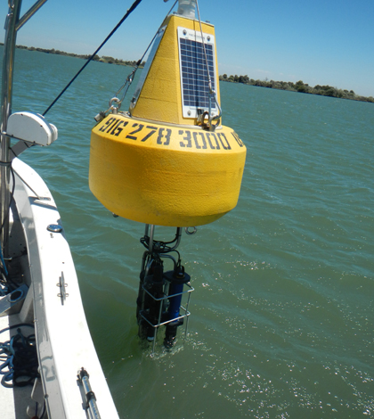
So far, the network consists of five stations within the Sacramento River portion of the delta. Each station is built on a USGS streamflow gauging site and supports a Satlantic SUNA nitrate sensor and WET Labs Cycle Phosphate sensor. A YSI EXO multi-parameter sonde at each site carries sensors for algal pigments, turbidity and dissolved organic matter. Measurements are collected every 15 minutes and transmitted online. The sensors are mounted on pilings channel markers. Where those structures weren’t available, the sensors are supported by NexSens data buoys.
")
Sensors at each station track nutrients, organic matter and turbidity, among other variables (Credit: USGS)
Many of the sensors, including those for nutrients and organic matter, are based on optical technology that has only recently been proven ready for “prime time,” Downing said. That makes the delta one of the few places in the world with a real-time nutrient monitoring network. Coupled with the streamflow gauging network, the optical sensors will give scientists a new perspective on how nutrients fluctuate throughout this hydrologically complex system.
Continuous water quality measurements in the delta have provided a new window into gaps between discrete monthly measurements, continuous habitat quality information and linkages between nearby sites in the San Francisco Estuary. The measurements yield important information on the timing, drivers and mechanisms of food web component transport and processing that are often missed by the sparse frequency of traditional sampling methods.
The network is already providing insights into the system that scientists were missing with manual sampling. The station at Liberty Island has been especially revealing. Dikes in this section of the delta once kept the land dry and farmable. The land was ultimately inundated after a series of dike failures in the 1990s.
Today, the shallow reservoir is seen as a valuable rearing habitat for delta smelt and and fish species. But scientists don’t know much about how it functions. Data from the monitoring station is helping to change that.
“Since installing this system, we’ve learned that Liberty Island can be a source and also a sink of nitrogen that can then be used by the food web downstream or upstream,” Saraceno said. “We actually see nitrogen retention in the summer as algae blooms.”
Downing says the data could eventually help construct computer models of how the system functions. It could also serve as a guide for the estuary’s manual sampling programs, which remain important. Meanwhile, the USGS has received funding to expand the network further downstream into the estuary. Other research groups plan to install similar stations in the system.
“This is a first,” Downing said. “And it’s key to getting a better grip on what’s happening in the delta and just how the whole system works.”
Image: A nutrient and water quality monitoring network in the San Francisco Estuary and Sacramento River Delta (Credit: USGS)


0 comments