
Hundreds of GPS devices tracking surface currents near Deepwater Horizon spill
Researchers at the University of Miami have placed more than 300 GPS devices in the Gulf of Mexico since summer 2012 to study surface flow and learn how pollutants behave in normal and hurricane conditions, according to a release from the school. Flow monitoring began to see how Hurricane Isaac moved contaminants left from the Deepwater Horizon oil spill.
The devices are deployed near the Deepwater Horizon site and track where and how fast drifts move. Findings will help emergency responders and government officials in the event of another spill, while protecting environmental health in the present.
The work is the largest research expedition studying ocean surface flow in the Gulf to-date. The Consortium for Advanced Research on Transport of Hydrocarbon in the Environment, funded by the Gulf of Mexico Research Initiative, will use the collected data to explain ocean flow and its role in pollutant dispersion following hurricanes.
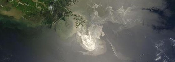
Image: A satellite image of the Deepwater Horizon oil spill in the Gulf of Mexico (Credit: NASA)


0 comments