Friday followup: California drought spoils waterfall erosion field research
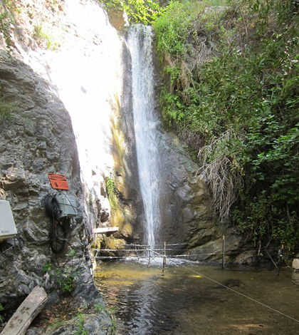
The waterfall in the San Dimas Experimental Forest where Sheingross' instruments have been denied the opportunity to measure a big sediment transport event. (Courtesy Joel Scheingross)
In January 2012, I talked to Joel Scheingross, a geology graduate student at California Technical University, as he was getting ready to instrument a waterfall plunge pool with pressure transducers. His plan was to measure how storm flows move sediment through the system, flushing out the pool’s gravel and exposing its bedrock to erosion. A better understanding of processes like that could have implications for everything from managing dams to back-dating water-carved features on Mars.
I emailed Scheingross recently to see how things have shaped up since then, and this is what I heard back:
Unfortunately, I don’t have much news to report. We’ve had three really bad drought years in a row in California, and have yet to have a single sediment transport event through the plunge pool I’ve been monitoring.
In a followup call, he clarified that there was likely some fine sand moving through the system, but he hadn’t seen a single event large enough — one that moved gravel and cobble — to get at the question he’s looking at.
Part of the issue is that he’s working in a small watershed in the San Gabriel mountains within the San Dimas Experimental Forest. The forest is closed to the public, so he could set up the equipment in one of its waterfalls without fear of vandalism or tampering. But the small watershed also means the stream hasn’t seen the high flows that have driven more substantial sediment action in plunge pools within larger watersheds in the same mountain range.
In the meantime, he’s completed work measuring erosion experimentally with a model riverbed in the lab, and he’s developed theories to explain those data. The hope was to see how well the theories lined up with data from the field. That hasn’t worked out yet, though that wasn’t a complete surprise.
“When we set out to do this project, we recognized that there was inherent risk in this type of field monitoring approach, which was always just a small piece of the larger picture,” he said.

A closer look at the plunge pool setup, including Airmar sonar depth sensors. (Credit: Joel Scheingross)
Some hope still remains. Scheingross is still around a year out from graduation, and the equipment is still in the pool and ready to capture any big events. Climate forecasters are predicting a slight chance for an El Niño this winter, which could bring more rain to California than usual.
But even if that doesn’t pan out, Scheingross says his colleagues won’t judge him too harshly for the lack of field data.
“At least in geology, people kind of understand that field work has lots of complications, and this is one of them,” he said. “You get some kudos for making the effort.”
Top image: The waterfall in the San Dimas Experimental Forest where Sheingross’ instruments have been denied the opportunity to measure a big sediment transport event. (Credit: Joel Scheingross)


0 comments