NASA prepares to launch eighth Earth-observing Landsat satellite
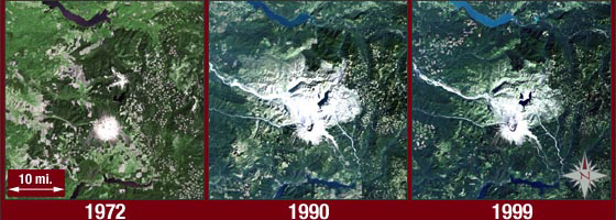
The Landsat satellite mission that has captured images of Mount St. Helens’ eruption and the expansion of tropical deforestation will continue to record changes to the earth’s surface as it preps for the launch of its eighth satellite.
NASA’s Landsat Data Continuity Mission is entering its 41st year as a joint mission between NASA and the U.S. Geological Survey. Its new satellite will have two new observational sensors and be more sensitive than ones in the past.
“Over the course of this mission, we have seen dramatic changes in the land surface of the earth,” said Jim Irons, NASA’s project scientist on the mission. “We’ve charted increases in population, advances in technology and the effects of climate change.”

An image of the Grand Canyon captured by the Landsat 5 satellite (Credit: USGS)
Irons says the new satellite will be more sensitive to new variations and changes in the earth’s surface and will enable image collection to increase to 400 per day. The enhanced sensitivity comes from the addition of two new sensors: an operational land imager and a thermal infrared sensor.
“This will be one of the best Landsat satellites launched in terms of the quality and quantity of data collected,” said Irons. “The two new sensors will help us record more changes to land surface over time.”
The operational land imager will take images in the infrared portion of the electromagnetic spectrum and will be able to observe high altitude cirrus clouds, water quality in lakes and shallow ocean waters and the presence of aerosols. The thermal infrared sensor has two thermal bands to record heat emitted from the earth, besting the single band available on previous satellites.
Enhanced capabilities will become more important as older satellites go offline. Landsat 5 was retired last month. Landsat 7, which was launched in 1999, is still functioning, but not without issues. Its operational efficiency is running around 80 percent, meaning that it misses some images.
“There’s a 22 percent data gap in each image we get from Landsat 7,” said Irons. “It’s sort of like a venetian blind pattern. But we’ve developed ways to mosaic the images together throughout the day so nothing is missed.”
Plans for future satellites are still being determined.

A global mosaic of three years worth of cloud-free images from Landsat satellites (Credit: USGS)
“We’re looking at options and alternatives beyond Landsat 8,” said Matthew Larsen, USGS associate director for climate and land use change. “That depends on the federal budget and needs moving into 2014.”
Landsat 8 will launch Feb. 11 from Vandenberg Air Force Base in California. Its images will be added to the mission’s archive of images that is open to the public. Downloads from that archive average 3 million per year. Following launch, USGS will take over control of its operations.
Top image: Landsat images of Mount St. Helens before and after its 1980 eruption (Credit: NASA)


0 comments