
NASA satellites capture California groundwater losses back to 2002
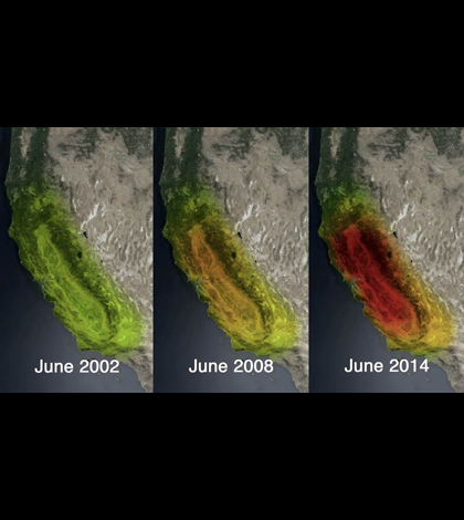
Twelve years of water loss in California based on data from NASA's GRACE satellites (Credit: NASA/JPL-Caltech/University of California, Irvine)
NASA satellite images show the loss of water stored in California since June 2002, according to NBC News. The images, which cover through June 2014, indicate that the state’s water losses began more than 10 years ago, instead of in 2011 as previously thought.
More than half of the losses have come from California’s groundwater supplies, NASA scientists say. The images don’t show good news for the Sacramento and San Joaquin River basins either, as those areas have lost about 4 trillion gallons of water in the last three years.
Images were snapped by NASA’s twin GRACE satellites, which typically collect data on Earth’s gravity. The space agency is planning to release a video to further illustrate the water losses in December 2014.
Image: Twelve years of water loss in California based on data from NASA’s GRACE satellites (Credit: NASA/JPL-Caltech/University of California, Irvine)


0 comments