New Water Scarcity Map Shows Issues Globally
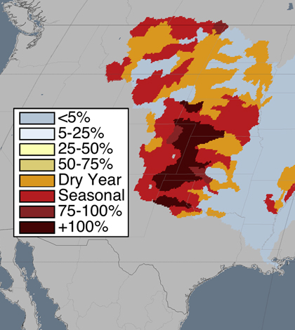
Mississippi River watershed with dry season data. (Credit: Kate Brauman)
A team of international researchers has charted water scarcity issues around the world and incorporated their findings into a single map for planners and policymakers, according to a release from the University of Minnesota. The new water scarcity map has a much higher detail than others out there, scientists say.
This is because other such scarcity maps only focus on the largest watersheds across the world. But the new map covers those while also adding in information on all the smaller ones existing globally.
The enhanced definition of the new map means that it’s possible to zoom in on specific regions and see if they are suffering from water overuse or lack of replenishment. The capability will help land and resource managers identify where steps need to be taken to safeguard against water shortages.
In addition to higher resolution, the water scarcity map also features seasonal and dry-year information.
Top image: Mississippi River watershed with dry season data. (Credit: Kate Brauman)


0 comments