
Lake Michigan has surprising effect on one of its tributaries
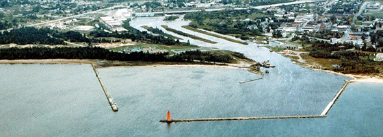
On the south shore of Michigan’s Upper Peninsula, a history of pollution from sawmills and other industries has left the Manistique River with a legacy of PCB-tainted sediment and sawdust circulating through the harbor and beach where the stream meets Lake Michigan.
State and federal cleanup efforts have been under way there since the 1990s, including extensive dredging under the U.S. Environmental Protection Agency. The dredging has cut PCB concentrations significantly, but some contamination still remains. A recent study in support of the next round of dredging looked at the way water, sediment and sawdust move around in the river and harbor. The results uncovered some strange behavior in the Manistique system that will likely affect how the dredging project unfolds.
One obstacle to cleanup efforts has been the murky picture of just where on the river bottom the toxic chemicals lie. Though it hasn’t yet been confirmed, past sediment sampling has suggested that the contamination is moving around.
“That makes it hard to come up with a remediation plan if you don’t exactly know where your hot spots are,” said Eric Anderson, a research physical scientist with the National Oceanic and Atmospheric Administration’s Great Lakes Environmental Research Laboratory. “If they were going to dredge this for some kind of remediation plan, they would need to know where the contaminated sites are so they could target them.”
A remediation strategy is an important step toward the next round of dredging planned under NOAA. That agency isn’t usually in the contaminant dredging business, said Julie Sims, Great Lakes regional coordinator for NOAA’s Restoration Center. But the sawdust qualifies the Manistique for the agency’s Marine Debris Program.
“It’s about thinking outside of the box and coming up with creative ways to solve a problem that otherwise doesn’t fit neatly into the boxes of what people normally do,” Sims said.
But before the agency can draw up a plan, they have to get a handle on the extent to which contaminated sediment and sawdust are moving around in the system. That’s where Anderson and the Great Lakes Environmental Research Laboratory come in. The lab houses hydrodynamic models of all the Great Lakes, and Anderson and other researchers there have experience creating fine-scale local models that can be connected to tributaries and plugged into the larger models.

Eric Anderson, research physical scientist with the Great Lakes Environmental Research Laboratory, with sediment samples on the Manistique (Credit: GLERL, via Flickr)
To collect the data needed for a Manistique model, the researchers deployed a bevy of monitoring instruments in the river, harbor and offshore area in the summer of 2012. The equipment included acoustic Doppler current profilers and water level loggers. The loggers were recording water levels once a minute for four months, and those high-frequency measurements helped uncover a peculiar trait of the Manistique that likely has a significant impact on how contamination circulates there.
Seiche surprise
One variable that the researchers were particularly interested in was the impact of seiche action on the river. A Great Lakes seiche is usually thought of as a bathtub-like sloshing motion that causes fluctuations in water levels brought on by high winds and atmospheric pressure changes. The phenomenon is tied to storm events that cause a rise in water levels in one part of the lake and a corresponding drop in another.
But where the Manistique meets Lake Michigan, the data show a seiche acting up dozens of times a day, whether there’s a storm blowing around or not.
“The Manistique, just because of the geometry of the harbor and the river system and its relationship to the lake, sees a seiche that oscillates on the period of about every 20 minutes. And it even reverses at some points,” Anderson said. “If I’m looking at trying to say how sawdust moves in this system, that’s a huge thing to know there’s this oscillating flow in the river system.”
Though there may have been some knowledge that the river periodically flows in the opposite direction, the discovery of just how often and how quickly the change happens surprised a lot of people, he said.
The next step is to build and calibrate the model to be able to reproduce the oscillating flow. Simulations from the finished model will help test the feasibility of a few cleanup strategies. The right plan could allow years of collaboration between federal and state agencies and the city of Manistique to culminate in the river’s removal from a federal list of Great Lakes Areas of Concern. The goal is to have a plan in place by October 2013 and have it carried out in 2014.
“We have a pretty ambitious timeline,” Sims said. “The hard part is we want to do a really good job, but we’re doing a lot of work on a really ambitious schedule.”
Top image: Aerial view of the Manistique River and harbor (Credit: U.S. Army Corps of Engineers, via Wikimedia Commons)


0 comments