
USGS study of Va. streams finds flaw in past streamflow measurement method
A study conducted in Virginia by the U.S. Geological Survey has found that the technique used to estimate groundwater’s contribution to streamflow consistently underestimates that figure by about 10 percent. The study could be used as a model for replication in other states and its results may help in national efforts to budget water.
The older technique, called a graphical hydrograph separation (GHS), has been commonplace in stream monitoring for decades. It involves measuring changing water levels and flow rates following storm events. Plotted against time, water level graphs usually show spikes after rainfall and then steady declines back to normal levels.
“After a storm event, rain water goes into the watershed,” said Ward Sanford, hydrologist at USGS and lead author of the study. “Some is recent rainfall, but not all. Two or three days after, a stream will still be flowing heavy. We found that’s due to groundwater.”
Sanford and others at USGS plugged data collected for 18 months from more than 70 stream gauges across the state of Virginia into a computer program that runs graphical hydrograph separations automatically.
")
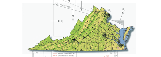
Estimates of mean annual effective recharge in Virginia by locality from 1971 to 2000. (Credit: USGS)
“Because there are so many water level records from GHS readings, there are auto routines we can run through a computer,” said Sanford. “We applied that program to our streams, and it said 60 percent of the water was from groundwater seepage and 40 percent was from rain.”
The USGS study used a different method to see if the GHS one was accurate—a chemical hydrograph separation (CHS). CHS tests rely on tracers in water, such as chemical isotopes and their concentrations. Sanford and other researchers used those markers to find the source of excess streamflow following storms.
“Fifty gauges across the state of Virginia consistently read rain’s contribution as 10 percent higher using the graphical method,” said Sanford. “The chemical method separates the baseload component better to show that groundwater contributes to streamflow more than thought.”
Sanford says the study can be used as a model for those in other states and in water conservation efforts.
“This is kind of a demonstration project,” said Sanford. “The USGS is thinking about ways to develop a water census for the country, broken down state by state and county by county. What we’re trying to get at is water availability, and it’s hard to manage water if you can’t measure how much is there.”


0 comments