
Alaska ocean data portal’s timely unveiling aids response to beached Kulluk oil rig
On New Years Eve, Shell’s Kulluk oil rig broke free of its tow line and headed for a small island in the Gulf of Alaska. Responders began to plan out retrieval operations as powerful waves battered the rig, which carried 140,000 gallons of diesel fuel and 12,000 gallons of lubricating oils and hydraulic fluid.
Meanwhile, the release date for the Alaska Ocean Observing System’s new interactive data portal compiling high definition data and multimedia was a week away. But the scientists, programmers and managers at AOOS knew this was no time wait around.
“We wanted to be able to provide the research to responders,” said Darcy Dugan, AOOS program manager.
AOOS worked closely with the Cook Inlet Regional Citizens Advisory Council to make sure responders to the beached rig had access to the digital Cook Inlet Response Tool even before its official release. The council wasn’t weren’t part of the official recovery operation, but they made a point to get responders access.
Susan Saupe, the advisory council’s director of research and science, said responders on Kodiak Island from Shell and Alaska Department of Environmental Conservation confirmed they looked at high resolution video to assess Sitkalidak Island even before the rig beached there.
“What we have is this great imagery of what the Alaskan coast looks like when the tide’s way out,” Saupe said.

The Kulluk sits aground on the southeast shore of Sitkalidak Island about 40 miles southwest of Kodiak City, Alaska. (Credit: Sara Francis/U.S. Coast Guard)
Location-based, high-resolution streaming video and photographs gave responders a way to view the island at low tide when they were first notified on the night of New Year’s Eve. It was still dark and U.S. Coast Guard fly-overs were hours away.
“If something’s happening and you’re in an emergency response situation, you don’t want to start from ground zero,” Saupe said.
She said the response tool gives responders a compellation of easily accessible data, so they never have to start from scratch on coastal areas affected by spills, or even beached oil rigs.
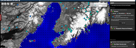
The Cook Inlet Response tool is based on an interactive map with layers of location-based data, photos and video. Twenty types of sensors feed real-time information such as wave and wind conditions. Historical biological data and oil spill response plans are also on tap for responders.
More than 30 state, federal and local agencies contribute data to the tool. “The big crux of our program is working with partners who are collecting data out in the field or sharing real-time data,“ Dugan said.
Data is uploaded to the interactive portal through open source software that allows the AOOS tool to tap into other organizations’ databases and source information automatically. This creates an environment of collaboration on a “data clearinghouse” with minimal legwork, Dugan said.
One parameter the inlet response tool does not cover is hydrocarbon content of water. There were no models or sensors available that AOOS could tap into for the interactive map.
Luckily, responders haven’t needed to use the oil spill response plans on the Kulluk. Tugboats successfully towed the rig off Sitkalidak Island to a safe harbor where the barge can be examined for damage.
A close call for the Kulluk meant a strong start for the Cook Inlet Response Tool.


0 comments