
Benthic Macroinvertebrates: Nature’s Water Quality Detectives Assisting Scientists
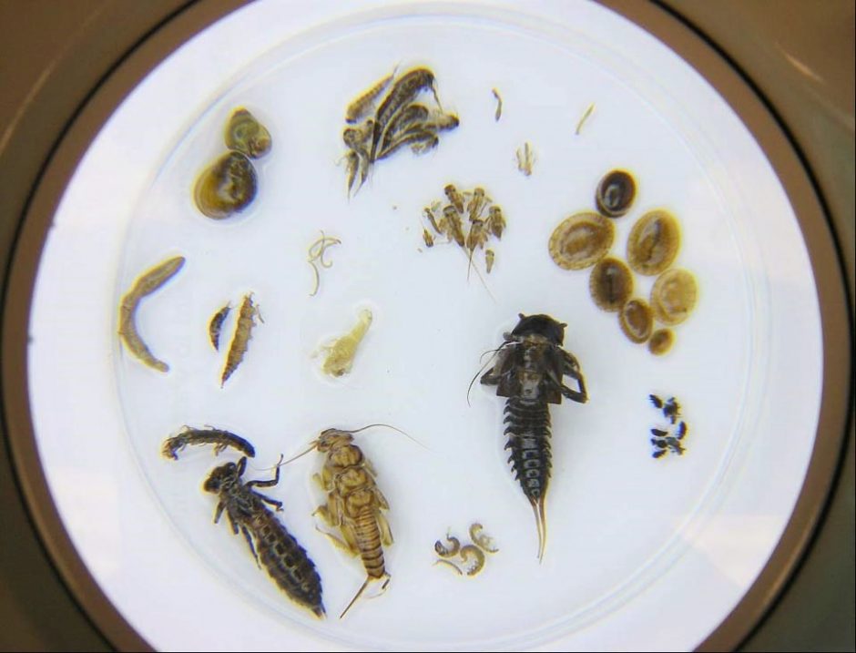
A number of benthic macroinvertebrates in a dish. (Credit: West Virginia Department of Environmental Protection)
Teeming communities of life inhabit the bottoms of nearly all waterways everywhere. Hidden from most observers, whether by lack of access or lack of awareness, these benthic macroinvertebrates form much of the foundation of any aquatic food web and ecosystem.
However, these tiny denizens of the nation’s waterways are also a mostly captive audience when it comes to poor water quality; they spend most of their lives in water, and unlike fish, cannot flee pollution or disruption. For this reason, scientists see benthic macroinvertebrates as indicators, nature’s water quality detectives. Biological assessments focusing on creatures like benthic macroinvertebrates are also more powerful and efficient than other kinds of monitoring, because they provide the opportunity to assess the cumulative effects of both physical and chemical factors—in fact, these assessments cover the entire gamut of ecosystem stressors.
Now, the Pennsylvania Department of Environmental Protection is visualizing the sampling results from benthic macroinvertebrate monitoring across the state for the first time; the data is now publicly available and downloadable here.
“Looking Below the Surface” in Pennsylvania
Dustin Shull, an aquatic ecologist and the Water Program Specialist for the Pennsylvania Department of Environmental Protection (DEP), is among those scientists using benthic macroinvertebrates to monitor water quality. The rich dataset he and others on the team produce with the help of these minuscule detectives is available online as part of an ESRI story map: “Looking Below the Surface.”
While [benthic macroinvertebrates] live in the water, they remain mostly sessile,” explains Shull. “Therefore, they experience the good and the bad without having the ability to ‘run away.’ When macroinvertebrate samples show groups of macroinvertebrates missing, it’s a good indication that something is wrong. Fish can avoid periods of acute pollution—episodes that are strong but temporally short—and move right back when the pollution moves downstream. So if DEP biologists only measured fish as an indicator of water quality, they could be missing these acute pollution events.”
Pennsylvania is home to about 86,000 miles of streams, and a high level of diversity between them. This diversity from stream to stream complicates the ecosystem integrity evaluation process. The DEP team has developed unique macroinvertebrate collection methods for limestone streams, freestone streams, and low-gradient streams to handle this issue, since these streams are all chemically and physically different.
“The macroinvertebrate communities that live in each stream type are also different,” comments Shull. “DEP strives to be as accurate and precise as possible when building water quality indicator tools, so each collection method is specially designed to capture macroinvertebrates where they are likely to be living in each stream type. This increases collection efficiency and repeatability. The metrics, or measures of biological condition, that are developed for each collection method are also specifically designed to compensate for the natural biological differences in each stream type, increasing the accuracy of the tool.”
“You won’t find too many states across the country with this many macroinvertebrate collection protocols—a fourth is on its way,” adds Shull.
Along with partners, DEP has collected thousands of samples, and hundreds more each year, to improve knowledge of the state’s water health. DEP partners with and accepts quality assured data from a number of sources, such as the US Environmental Protection Agency, the US Geological Survey, the US Park Service, the Delaware River Basin Commission, the Interstate Commission on the Potomac River Basin, the Ohio River Valley Water Sanitation Commission, the Susquehanna River Basin Commission, and many colleges, universities, and county conservation districts.
Collecting samples is a hands-on process.

Collecting samples with d-framed nets, while wading in the stream. (Credit: Shull/DEP)
“Samples are collected with d-framed nets, while wading in the stream,” Shull describes. “Depending on the method, biologists either kick the substrate upstream of the net and macroinvertebrates go in, or the net is jabbed through the habitat to collect the macroinvertebrates.”
The benthic monitoring program makes use of both the most basic equipment and more advanced technologies as it works to update the data collection process with the times.
“One of the great aspects of macroinvertebrate data collection is its cost effectiveness and efficiency,” remarks Shull. “In field, biologists need waders, boots, a collection net, jars, and preservative, just to name the essentials. DEP is also seeking to modernize this process with the use of mobile data collection devices that can collect field information such as field chemistry results, habitat results, and comments, as well as GPS locations and pictures.”
Once the in-field collection process is complete for a given site, the collectors transmit their information from the field directly to central DEP databases. This greatly increases work efficiency, reducing data entry errors, and virtually eliminates the need for paper forms. The collector then preserves macroinvertebrate samples in the field, and returns to the laboratory. Once in house, biologists sort and identify the macroinvertebrates with pans and compound microscopes.
Benthic detectives and the way forward
The benthic community is teaching scientists about how the biggest water quality challenges in the region really affect local aquatic ecosystems.
“The three largest impacts to water quality [in this region] are mining, agriculture, and development—not necessarily in that order,” Shull states. “As shown in the macroinvertebrate story map, areas of urban land cover and agricultural land cover produce some of largest areas of poor biological condition. The impacts from mining and abandoned mine drainage produce acidic waters with toxins that impact miles of streams. The macroinvertebrate community will express these impacts by the loss of pollution intolerant organisms, or even whole groups of macroinvertebrates. For example, a healthy macroinvertebrate sample might show 30 unique taxa, but an unhealthy macroinvertebrate sample might show only 5 unique taxa.”

Screen shot from “Looking Below the Surface,” an image of 17 macroinvertebrates. (Credit: DEP)
This kind of information is useful for scientists who need to focus research and tailor conservation plans. It is also crucial for land use planners, who need the data to make better decisions. However, the project was inspired just as much by DEP’s commitment to transparency, and to presenting accurate, up-to-date data for the public in a format that is easy to understand, despite the challenges posed by stagnant funding and staffing.
“Story maps provide the flexibility for users to spend as much or as little time they want on each topic; however, DEP encourages users to take some time and zoom around these fully interactive maps,” Shull elaborates. “Find places of interest and explore the data that’s now available. Once you zoom in, the maps provide more information; click on a stream to see its name, or click on a sample point to see which method was used to collect it.”
The DEP wanted to seize the compelling visual power of the ESRI story maps to share information about the fascinating undersea world of benthic macroinvertebrates in a way that is compelling and visually stunning.
“This project is only the beginning,” Shull promises. “Stay tuned for more interactive story maps coming out of DEP, all designed to provide the public with critical information and a great learning experience. DEP encourages the public to check out other impactful story maps and interactive reports that have already been created, too.”
One Comment
Leave a Reply


Pingback: FishSens Magazine | Study: Lake Dredging and Other Ecological Harms - FishSens Magazine