Hurricanes Are Changing Puerto Rico’s Watersheds
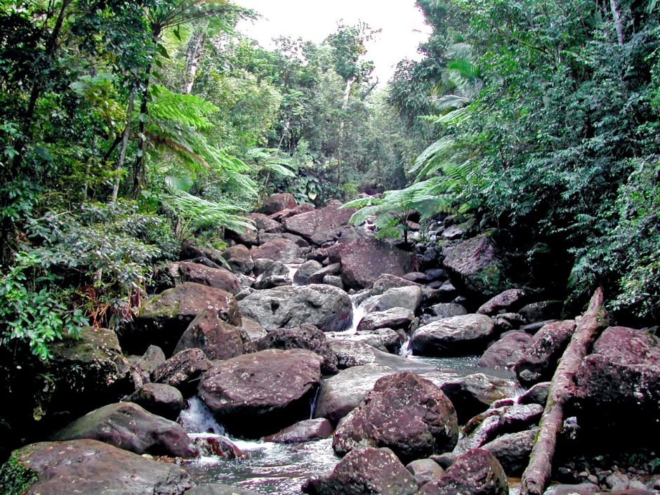 Aquatic sensors are used in streams like this one, Quebrada Sonadora, which is one of the study sites in the Luquillo Mountains of Puerto Rico where researchers monitored nitrate levels before and after Hurricanes Irma and Maria. (Credit: William McDowell/UNH)
University of New Hampshire (UNH) researchers have been studying the watersheds of Puerto Rico for some years now. Now, new work from the team reveals unprecedented high levels of nitrate in waterways on the island following the two major hurricanes of 2017. Dr. William McDowell, a professor of natural resources and the environment at UNH, spoke to EM about the research.
“This started many years ago, early in my career when I lived and worked in Puerto Rico,” explains Dr. McDowell. “I established these long-term study watersheds, a few which we continue today, and more recently we’ve added other sites. The focus has been on understanding how stream chemistry, which represents this important transfer of materials, solutes, and sediment from up on the mountain down these steep rivers and then very quickly onto the coast.”
In other words, the idea has been to identify what’s in the stream water load, and what nutrients, products from the dissolution of the rocks, soil material, and other sediment is moving downhill from the mountain into the sea.
“Secondarily, it’s also useful to think about how the river reflects what’s going on in its watershed,” details Dr. McDowell. “We’ve known for decades that streams are sensitive to what goes on inside their watersheds in terms of the forest health, big human events, or human activity. This is important from the perspective of the organisms that live in the stream, as well as understanding how the plants and animals in the watershed itself are affecting what’s in the stream.”
In this sense, the waterways of Puerto Rico are a sort of a central conduit that reaches out across the landscape from the top of the mountain down to the coast. Dr. McDowell and the team studies how those parts are interconnected, and what happens to them when a big hurricane hits the island.
“The first one we studied was in 1989, Hurricane Hugo,” states Dr. McDowell. “Hurricane Georges in 1998 was our second biggest over the last 30 years, it had more rain and a little bit less wind than Hugo.”
Now, Puerto Rico has been hit by the one-two punch of Hurricane Irma and Hurricane Maria, which both had devastating impacts on the human infrastructure of the island—and its natural resources.
“They’ve very significantly affected the forest,” Dr. McDowell describes. “This forest, this set of trees, and these communities of trees that are sorting themselves out by elevation have been around in the Caribbean for a long time. They’ve had hundreds of thousands of years worth of hurricanes to hit these islands, and so, of course, the trees that are there, by definition, must be adapted to be able to deal with hurricanes.”
But what if the historic frequency of hurricanes is changing? If bigger, more damaging hurricanes are hitting Puerto Rico, can its forests recover?
Monitoring nitrogen in water, and trees, by extension
One of the issues that Dr. McDowell and colleagues who study trees are concerned about is whether the period of intense hurricane activity from 1989 until today that they have observed—three big storms in 30 years, one every 10 years—is a much higher frequency than what the historical records appear to suggest, which is one storm every 60 years.
“We’re carefully watching as we see the trees and the stream chemistry come back, although it hasn’t gone back to baseline yet,” comments Dr. McDowell. “We’re looking for signs of whether we may really be seeing a long-term shift in the function of the whole system, that this has just been a little too much to expect it to go back to any kind of baseline anytime soon.”
This is where long-term monitoring adds so much value to the conversation.
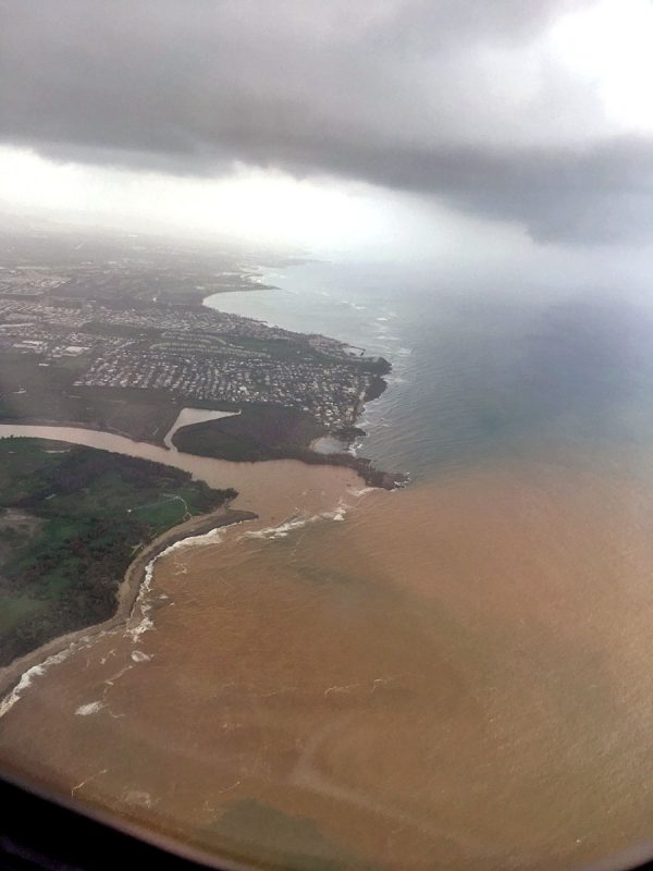
Aerial photo of the coastline of Puerto Rico that shows one of the many streams and rivers that lead down from the mountains to the ocean. (Credit: William McDowell/UNH)
“My colleagues have been studying a forest plot for 25 years now, where every tree is marked and tagged, and they assess it every five years,” remarks Dr. McDowell. “As soon as the hurricane hit they went back out there, trying to measure the extent of the damage in these 16 hectares, about 25,000 stems I think.”
As the team watches, they are hoping to answer a fundamental question: How closely does the nitrogen in the stream reflect what’s going on in the forest?
“We think it is a close connection, and we’ve published past studies where we’ve manipulated the forest at the plot scale simulating a hurricane or elements of a hurricane, and we see that we can generate this pulse of nitrate that lasts a while and then goes back down after the first year, and all the way down after 16 months,” relates Dr. McDowell. “We’re pretty sure that the driver of what we see in the stream is really the dynamics of the forest. The data we’re collecting now suggest that as well, and it will be really interesting to see whether there’s slower regrowth of the forest that is corresponding to this period of elevated concentrations of nitrate that is just kind of bleeding out of the system.”
In fact, the team’s working model is that by monitoring water chemistry, you can “read” what has gone on around the stream—at least as far as what was going on with the trees in the vicinity.
“It’s a fact: if you disturb or damage the forest, the nitrate flushes out,” Dr. McDowell says. “We’ve published that previously at our site, but it’s also been shown to be true for forests with ice storms or cutting them down, or insect defoliation, so this is a widely established principle. What we’re seeing, though, is that the response of the forest seems to be bigger and lasting longer than what we’ve seen in the past two major hurricanes.”
You might reasonably expect some kind of dramatic response if you were cutting trees down, but assuming that hurricanes are part of the natural process, a dramatic reaction seems strange.
“Looking across a bunch of sites where people have made these long-term measurements, that’s what I decided the most surprising thing was,” adds Dr. McDowell. “Even in this system that is adapted to hurricanes, we get this big flush of nitrate out. And now it’s even bigger than before.”
Hurricanes and nitrogen in water
The researchers have two ways to determine what the nitrate levels in the water are.
“We’re using an in-situ, fancy, expensive sensor,” explains Dr. McDowell. “It’s new technology that wasn’t even available ten years ago, and it measures the nitrate specifically every 15 minutes. The more standard method is to take a physical water sample every week from the stream, and then take it back to the lab and analyze it.”
In fact, the team has more than 30 years of data from some sites.
“One part of the project is focused more on the ecology of the trees, animals, and plants in these watersheds, and I do the part about biogeochemical cycles,” details Dr. McDowell. “We also measure things like the rain chemistry, and throughfall, which is rain after it passes through the forest canopy, and soil solution. We’ve been measuring all of those for 10 to 30 years, depending on which thing we’re talking about.”
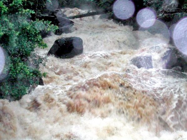
The usually tranquil Quebrada Sonadora stream, one of the study sites for the aquatic sensors, now raging with rushing, muddy water just after a storm. (Credit: William McDowell/UNH)
The researchers had employed their real-time samplers in time to capture the most recent hurricane events.
“They made it through the storms, we’re very proud of the fact that we were able to keep them, we didn’t even consider pulling them out because we really want to capture these extreme events,” Dr. McDowell describes. “We were fortunate enough and our engineering is good enough that we made it through. We suffered a bit of damage, but no catastrophic failures. So we have a lot of data from right through the storm. That’s really helpful to have, and no one’s really had that before.”
According to Dr. McDowell, the behavior of the streams after the storms, specifically the nitrate concentration, went up after each rainstorm. That’s a new behavior too—one that hasn’t been demonstrated before.
“Right now, we’re very sure, from both of our traditional sampling of water taken from the stream and analyzed in the lab, and the sampling from the sensors, that we have an elevated concentration of nitrate,” adds Dr. McDowell. “The elevation of nitrate is lasting longer than we’ve seen in past hurricanes, so it seems to be a stronger, bigger response to this particular set of storms than we’ve seen from the past ones. Also, with the sensor, we can really characterize a very steady and stable baseline condition, and then during individual storm events, it goes up and down. We hadn’t been sure of that in the past.”
Since the nitrate level hasn’t returned to normal, it is uncertain what that will mean for the trees—but it is suggestive.
“We have to say that it’s a distinct possibility that another one if it happened this year, would be really a harsh blow for the island, that’s for sure,” remarks Dr. McDowell. “It would be likely to have significant impacts on the forest and the stream chemistry. A huge impact on the people who live in Puerto Rico. We are keeping our fingers crossed and hopefully, we get a little bit of a breather for at least a few years. Because it was really grim, I mean for months we weren’t really even sure how people were doing. It gets pretty old pretty fast.”


0 comments