Monitoring threatened crustacean’s cave habitats reveals surprises in Virginia karst formations
Water quality monitoring setup in a Virginia cave (Credit: Wil Orndorff)
A few caves nestled in the Shenandoah Valley support the only known populations of the Madison cave isopod, a threatened freshwater crustacean. New development near two of those caves in Virginia prompted water quality monitoring efforts to track impacts on the isopod’s habitat, and the results weren’t what scientists expected.
Though the Madison cave isopod swims in the freshwater of subterranean karst aquifers, its closest relatives are marine isopods. That means its lineage dates back to a time when higher sea levels exposed the Shenandoah Valley–which is now hundreds of miles inland–to saline or brackish water.
It’s difficult for geologists to say just how long ago that was because the valley lies in the actively-uplifting Appalachian Mountains, according to Wil Orndorff, the kart protection coordinator for the Virginia Department of Conservation and Recreation’s Natural Heritage Program.
“And they’re eroding as they uplift, so most of the evidence for when that marine water was in contact with the Shenandoah Valley has probably been destroyed,” Orndorff said. “So this Madison cave isopod really becomes sort of a living fossil.”
Orndorff said geneticists have analyzed the isopod’s DNA and used mutation rates to identify when the isopod split off from its marine ancestor. They came up with sometime between 20 million to 75 million years ago.
“There’s a huge, huge range, but the point is it’s not recent,” Orndorff said. “You’re talking about something with a very old lineage.”
The caves like those that harbor the isopod are a common feature in the region, where the soluble limestone bedrock is weathered into karst formations like caves and sink holes. That has big implications for how water moves across the landscape. It often travels underground rather than in surface streams. As a result, karst systems fairly sensitive to contaminants, which can move quickly and directions that are difficult to predict.
")
The exposed water table in a cave called Power Plant Pit (Credit: Virginia Department of Conservation and Recreation’s Natural Heritage Program)
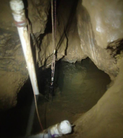
Orndorff and his colleagues were concerned when they learned that a power plant under construction would be discharging storm water into features connected to the locations where we the Madison cave isopod had been observed. To get a handle on the potential impacts, they outfitted three cave fissures with monitoring equipment that continuously measured water levels, temperature, conductivity and turbidity in the exposed water table.
The caves presented some access issues. The scientists had to rappel into one study site, while another required a crawl through a 9-by-22-inch hole half filled with water
“It’s kind of nasty,” Orndorff said. “I don’t particularly like that spot. But then you go on a little farther and you get to the fissure and it’s all good.”
So far, the data have been surprising. Two of the caves are near the power plant and within 100 meters of each other, and Orndorff said they expected the two water bodies exposed in the caves would respond very similarly rainfall event. But that wasn’t the case.

Tight working conditions in the Power Plant Pit (Credit: Virginia Department of Conservation and Recreation’s Natural Heritage Program)
Water in one of the caves responded much like surface water would. After a storm, turbidity would rise and conductivity would fall as the dissolved minerals were diluted. The water got warmer in the summer and colder in the winter.
Just 100 meters away at the other cave, turbidity stayed constant and conductivity actually rose after rainfall. This suggests that the first cave has a strong connection to surface storm water inputs, while the other responds to rain by forcing water from deep in the aquifer to come up to the surface.
“We really expected that both caves would be equally affected by surface disturbance because of their proximity. And they weren’t,” Orndorff said. “It also taught us that the species is probably more tolerant of a variety of environments than we thought it was.”
Top image: Water quality monitoring setup in a Virginia cave (Credit: Virginia Natural Heritage Program)


0 comments