
Mosquito flux meter gives clues to tectonic activity off the Washington coast
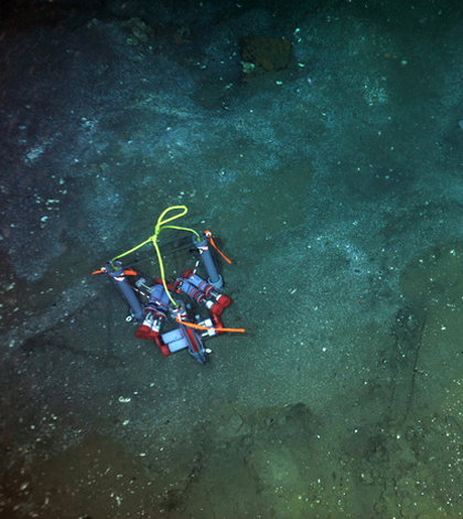
A Mosquito meter on the seafloor of the coast off the Pacific Northwest (Credit: NSF-OOI/UW/CSSF)
Off the coast of Pacific Northwest, the Juan de Fuca tectonic plate is sliding under the North American Plate at a rate of about 4 centimeters a year. Except where it isn’t. There’s a “locked” zone along this fault where the plates are resisting movement, storing up energy that, if released all at once, could produce an earthquake large enough to rattle the coast from Vancouver to Sacramento.
The subduction zone is deep below the seafloor, which makes it difficult know just where the boundaries of the locked area lie. But water flowing up through the ocean sediment carries signatures of the plates’ activity, and novel data-collecting instruments are helping marine geologists decipher those signatures with greater clarity.
One of those tools is the mosquito flux meter, named for the proboscis-like needles that extent from its frame down into the sediment. The meter can withstand multi-year deployments on the ocean floor, continuously drawing and storing samples of water that has percolated up from the crust.
Those long deployments, and even shorter missions lasting days, give a much more detailed picture than other methods, according to Daniel Culling, a staff researcher with the University of Washington’s School of Oceanography. Much of this analysis has previously been conducted on sediment cores, which just give a one-time snapshot of what that water looks like.
“[The core] gives you no idea of what this does over time, which is essentially the most important part of this instrument,” Culling said. “The Polaroid is the old way of doing this, and we’re using a video camera. Adding a different dimension to the measurement is really important.”
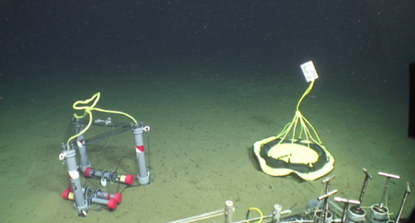
A mosquito meter, left, on the seafloor of the coast of Washington (Credit: University of Washington)
Culling works on mosquito meter deployments with Evan Solomon, assistant professor of oceanography at the University of Washington. Miriam Kastner, a professor of geology at Scripps Institution of Oceanography, developed an early version of the instrument.
During past applications, the mosquito’s needles have sunk 17-35 centimeters into the sediment and, powered by osmotic pumps, drawn continuous samples that are stored in teflon coils. Once the instrument is retrieved, the coils are processed and analyzed for chemical constituents such as chloride, sulfate, calcium, methane and silica, just to name a few.
The meter can also help researchers estimate the direction and rate at which the water is flowing in the sea floor. One needle injects a tracer dye into the sediment that is eventually taken up by other needles placed at different depths and locations around the injection site. By calculating the time it takes for the dye to arrive at each needle, the researchers can determine which direction the water was flowing and how quickly.
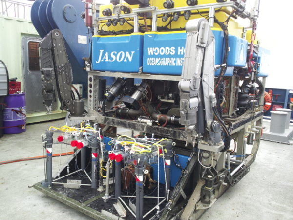
Two mosquito meters loaded on the Woods Hole Oceanographic Institution’s JASON ROV (Credit: University of Washington)
During an August 2013 research cruise off the Washington coast, scientists from the University of Washington and Oregon State University deployed 23 mosquito meters in a line running perpendicular to the fault, spanning the subduction zone. Data from the flux meters and a number of other instruments deployed on the cruise will help refine scientists’ ideas of the locked zone’s size and location. So far the results suggest that the Washington section of the zone is narrower and farther offshore than previous estimates.
“We’ve not associated our data with when another earthquake is going to happen,” Culling said. “But one step at time. We do have preliminary results that show quite well the abilities of this instrument over any other technique.”
Top image: A Mosquito meter on the seafloor of the coast of the Pacific Northwest (Credit: NSF-OOI/UW/CSSF)


0 comments