
NASA maps Typhoon Haiyan damage in the Philippines
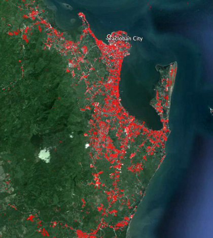
Red areas on the map reflect the heaviest damage (Credit: ASI/NASA/JPL-Caltech)
NASA’s Jet Propulsion Laboratory collaborated with the Italian Space Agency to map damage to the Philippines from Super Typhoon Haiyan, according to a NASA release.
The agencies used a combination of historical GPS and satellite radar data to determine how much damage the typhoon caused.
The Advanced Rapid Imaging and Analysis computer program, created by the Jet Propulsion Laboratory, was used to analyze landscape data and detect changes.
Satellite imaging showed much of the Philippine’s east coast near Tacloban City was damaged from the typhoon.
Super Typhoon Haiyan hit the Philippines on Nov. 8. The country is still recovering from the powerful storm, which displaced 4 million people.
Image: Red areas on the map reflect the heaviest damage (Credit: ASI/NASA/JPL-Caltech)


0 comments