
NASA radar analysis characterizes oil slicks for more targeted cleanups
A team of NASA scientists using radar to characterize oil spills has created a new analysis technique that will help disaster cleanup methods, according to a NASA news story.
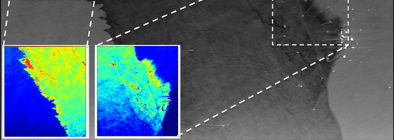
Researchers found that they could characterize how much oil was on the surface of the ocean by analyzing the roughness of water surfaces and the electrical conductivity of water.
They used the Uninhabited Aerial Vehicle Synthetic Aperture Radar developed by NASA’s Jet Propulsion Laboratory for radar images. Darker colors in a radar image indicate slick, oil-topped water, while light images indicate rougher ocean water. Electrical conductivity variations give scientists an idea of how much oil is in the area.
The new characterization method will help future oil spill recovery by giving cleanup teams an idea of which areas of the ocean have the most oil on the surface. Thin sheens of oil break down and evaporate quickly, requiring less cleanup. Areas with thicker oil emulsion, where oil and water mix and form a layer, require more intensive cleaning efforts.
Image: NASA UAVSAR image of the Deepwater Horizon oil spill. The oil appears much darker than the surrounding seawater. (Credit: NASA/JPL-Caltech)


0 comments