NASA Satellites To Dissect 2015 El Niño Better Than Ever Before
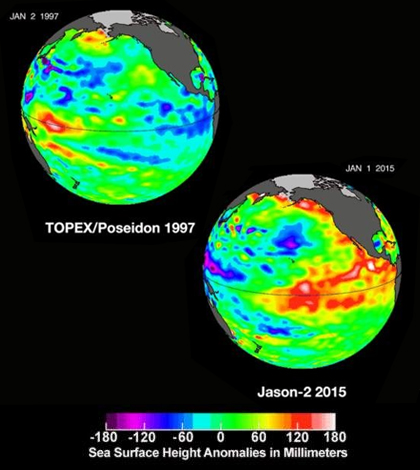
Comparison of 2015 sea surface height with the famous 1997 El Nino. (Credit: NASA's Jet Propulsion Laboratory)
El Niño has been appearing every 2 to 7 years, not only warming oceans but influencing weather events all over the world, including hurricanes, droughts and storms everywhere from the U.S. to the Philippines to Australia. Since the strongest El Niño event in 1997 to 1998, NASA has launched 19 satellites to observe El Niño and other phenomena, according to a release.
The 19 satellites combined with supercomputer processing for modeling climate systems will give scientists more analytical tools for monitoring and analyzing this year’s El Niño than ever before. Data that will be collected include sea surface temperatures, sea surface height, surface current direction, atmospheric wind movement and ocean coloration.
All of the data will give a global picture of El Niño activity and severity which was never before possible. Especially important is that the global data gathering will allow researchers to track droughts, improve warnings of impending floods and monitor fisheries and farmlands.
Top image: Comparison of 2015 sea surface height with the famous 1997 El Niño. (Credit: NASA’s Jet Propulsion Laboratory)


0 comments