New Mexico Scientists Raced Toxic Animas Plume, Gathered Valuable Baseline Data
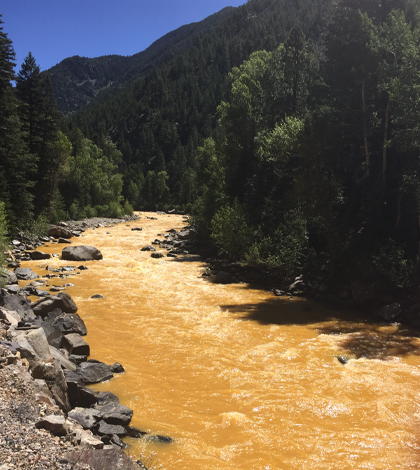
The Animas River between Silverton and Durango in Colorado, within 24 hours of the 2015 Gold King Mine waste spill. (Credit: Riverhugger via Creative Commons 4.0)
As toxic waste from a long-shuttered gold mine made its way down the Animas River this past August, communities along the waterway shut off their irrigation operations ahead of the orange plume’s arrival. The move was meant to protect public health, but had an unintended side effect: It gave scientists at New Mexico State University a truly rare opportunity to gather baseline data before the toxic plume got there.
Their target areas were ditches along the New Mexico stretch of the river. They rushed to sample them not long after learning about the Gold King Mine spill near Silverton, Colorado. By getting there while irrigation was shut off, the scientists ensured that none of the data collected would reflect any infiltration by pollutants flowing in the river.
Sampling began Aug. 7, just two days after the abandoned Gold King Mine had released its polluted waste into the river. And now, months after the accident, the researchers are surprised by a lack of funding to remediate the affected areas.
“One thing I’d like to emphasize is that although it has been nearly three months since the spill, no major federal assistance has been allocated,” said April Ulery, professor of soil and environmental sciences at New Mexico State. She worked with Kevin Lombard, an associate professor of horticulture at the university, to gather the valuable baseline data.
“No major funding has come down the pipeline. I’m personally invested in it as a scientist and a landowner, but funding wasn’t thought of when we started,” said Lombard. “That’s probably not the best way to do science, but when you’re faced with something you’ve never seen before in your life, it’s our obligation as community members.”

New Mexico State University employees from the Agricultural Science Center at Farmington help to take soil samples in irrigation ditches while gates were closed. (Credit: Jane Moorman / New Mexico State University)
And so with that sense of fervor at their backs, the two led a sampling effort that raced against the clock to collect data on soil health in irrigation ditches before the plume passed their stretch of the river. A GPS receiver helped them tag the sites they worked in. From there, most of the actual sediment samples were gathered with stainless steel soil augers approved for use by the U.S. Environmental Protection Agency.
The efforts covered nearly 20 ditches on and off the Navajo Nation in northwestern New Mexico and scientists were able to gather somewhere between 200 and 300 samples. They are approaching analyzing them with the hypothesis that pollutant levels in the soil won’t go up over time, something that they can only hope turns out to be true.
“I want to know the impacts of the contaminants to the farm fields. And those dry-ditch samples we retrieved pre-plume, we’ll never be able to grab again,” said Lombard. “Many of us farm. Some of my staff raise livestock and so we had access to community ditches before any response teams could get there, including the (U.S.) EPA.”
Ulery says that their work was part of a collaboration between state agencies including the New Mexico Cooperative Extension Service, the New Mexico Environment Department, the New Mexico Department of Agriculture, and the New Mexico Office of State Engineers.
“The big story for the New Mexico agricultural department was that the water cleared fairly quickly. That’s why the order was given to open irrigation,” said Ulery. “But that doesn’t mean that the metals are gone. They’ve just precipitated into the streambed and onto the river banks.”
Metals that passed through in the water, which Lombard likened to macaroni and cheese in color, included lead, iron, aluminum, arsenic, and copper. In the river, levels of these metals spiked with the plume’s arrival and dropped as it passed.

Kevin Lombard, middle, looks over soil sample data from an X-ray fluorescence spectrometer with researchers from the Navajo Nation EPA and Texas Tech University. (Credit: Jane Moorman / New Mexico State University)
Lombard says that the closer you got toward the source, the higher the sediment levels in the river were. But once the plume had passed, there were still notable impacts left behind.
“We were seeing orange sediment along the river banks. And that’s not to panic anybody, but we want folks to be concerned about public health and their livelihoods,” said Lombard. “We’ll make recommendations on remediation if it’s needed at all, but there are still sediments that could wash into irrigated fields. That’s why it’s important to resample every year.”
But first the researchers will have to work through analyzing all of the samples they currently have. Preliminary analysis of the soil samples has been supported by emergency funding from the New Mexico State University Agricultural Experiment Station and a small grant from the Natural Resources Conservation Service of New Mexico. Future funding will be necessary to complete these analyses and accurately evaluate long-term impacts to the region.
“There’s no fast turnaround on getting either the water or the soil data. Kevin and colleagues did some portable samples, but we still need to acidify and digest them in the lab,” said Ulery.
She says that it is also daunting at the outset because of varying reporting practices between agencies regarding the metals that washed through the Animas River. For example, some reported both total metals (including dissolved as well as in the particulates in the water) while others didn’t. “We were also answering basic questions about the difference between parts per million and parts per billion,” said Ulery. “That confusion led to a lot of worry and concern.”
It also underscored the rare nature of the type of disaster scientists were facing.
“Federal agencies don’t usually cause accidents,” said Lombard. “It’s a great case study.”
Top image: The Animas River between Silverton and Durango in Colorado, within 24 hours of the 2015 Gold King Mine waste spill. (Credit: Riverhugger via Creative Commons 4.0)


0 comments