
New National Weather Service forecast model zeros in on severe storms
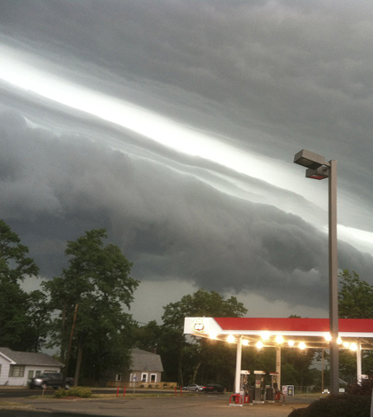
This pciture from LaPorte, Ind. show the leading edge of a derecho that eventually blew over Washington, D.C. (Credit: Kevin Gould / NOAA)
In late June 2012, a violent line of thunderstorms known as a derecho swept through Washington, D.C., prompting officials in the District, Virginia and Maryland to declare a state of emergency. The storm, which left more than 1 million people without power, was picked up by an experimental weather forecast model: the High-Resolution Rapid Refresh, developed by NOAA’s Office of Oceanic and Atmospheric Research.
“The HRRR actually had a very good forecast for [the D.C. storm event],” said Stan Benjamin, a research meteorologist at NOAA’s Earth System Research Lab and lead scientist on the HRRR. “Even though it was an experimental model, it picked up the storm in real time.”
Using data from a system of radar, satellite sensors and aircraft, the HRRR (pronounced “her”) provides hourly forecasts for the lower 48 United States at a resolution of three kilometers. That’s four times sharper than its predecessor, which allows the HRRR to identify whether a thunderstorm is rotating. Rotating storms are often more severe than non-rotating storms
NOAA’s Office of Oceanic and Atmospheric Research in collaboration with NOAA’s National Weather Service have been developing weather models for more than 20 years, Benjamin said.
“Until 1994, NOAA didn’t have any weather models that updated more frequently than once in 12 hours,” he said.
From 1995 to 2007, the NOAA worked with an hourly refresh forecast model. Several advancements in technology and methodology allowed for development of the HRRR to begin around 2007, Benjamin said. Those advancements included better data assimilation, higher resolution models, and the centralization of radar data for more efficient dissemination.
“We actually already had a community weather model at that point that could produce realistic thunderstorm evolutions with rotation,” Benjamin said.

A composite of radar images of the June 29 derecho (Credit: NWS/Storm Prediction Center)
The advancements that facilitated the development of the HRRR would have been futile, however, without an array of powerful computers to perform the necessary calculations and process data.
The weather service uses the HRRR alongside its predecessor, the Rapid Refresh, a forecast model with a wider area but a coarser 13 kilometer resolution. Although the HRRR has a little more than four times the resolution of the Rapid Refresh, the computing requirements for the newer model are 64 times higher. To obtain this power, NOAA partnered with the Federal Aviation Administration, which needed better aviation forecasts, Benjamin said.
“The aviation folks have been the big drivers for having hourly weather models,” he added. “Using frequent weather data from commercial aircraft has been particularly important allowing NOAA to develop increasingly accurate hourly refresh weather models.”
Despite not yet being approved for widespread use, the HRRR has already helped forecast several severe weather events, including the derecho that struck Washington, D.C. and a flood event in Oregon and Washington.
Benjamin and his colleagues at NOAA Research and the National Weather Service see the HRRR as a versatile forecasting model with applications in the energy industry, aviation and hydrology. The HRRR, however, is not a finished product, and Benjamin said several improvements are in the works.
“We’ll be doing more and more multiple model runs at the same time,” Benjamin said. Using a technique known as ensemble forecasting, the HRRR could be run up to 20 times every hour.
Although the HRRR is “already in every weather station in the lower 48 states,” Benjamin said it’s not yet available 100 percent if the time. That will occur when the HRRR becomes fully operational on National Weather Service computers later in 2014.
Top image: This picture from LaPorte, Ind., shows the leading edge of a derecho that eventually blew over Washington, D.C. on June 29, 2012 (Credit: Kevin Gould/NOAA)


0 comments