New Sea Ice Forecasting Method 40 Percent Better Than Older Ones
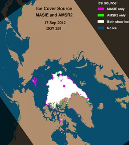
Sea ice cover from a single day in 2012. (Credit: NSIDC)
A coordinated effort by scientists at the U.S. Navy, University of Colorado at Boulder and the National Ice Center has led to improved sea ice forecasts for the Arctic that are at least 40 percent better than previous methods, according to a release from UC Boulder. The improved ice forecast will make navigating the Arctic safer for ships, an especially important development now that shipping activity has increased there.
The dramatic improvement comes about through blending of several data streams. High-resolution satellite data provided by the Advanced Microwave Scanning Radiometer 2 were combined with Multisensor Analyzed Sea Ice Extent, which includes human interpretation of satellite images and other information.
The resulting combined data sets provide much better accuracy, scientists say. For example, melt ponds on ice are no longer mistaken for ocean. Also, small patches of sea ice only a few miles across can be seen with the combined approach.
The new method was used successfully by the U.S. Navy this summer and is viewed as a beneficial tool for the whole community of ice experts and those with Arctic investments.
Top image: Sea ice cover from a single day in 2012. (Credit: NSIDC)


0 comments