
Ocean-faring Wave Gliders could boost tracking of globally important phytoplankton trends
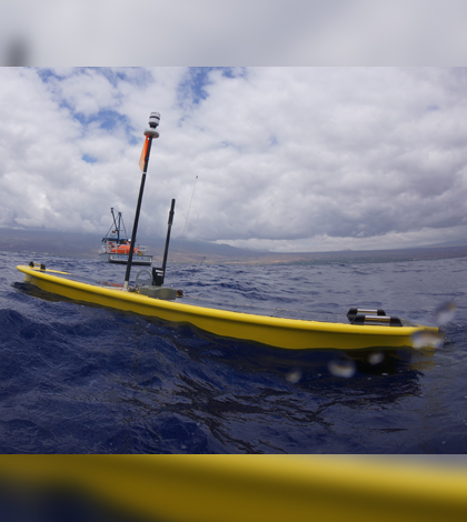
The Wave Glider platform developed by Liquid Robotics (Credit: Liquid Robotics)
Four Wave Glider autonomous marine vehicles spent most of 2012 bobbing across the Pacific Ocean and collecting oceanographic measurements. It was a record-setting journey meant to demonstrate the technology and set scientists loose on the data.
A recently published study using data from the expedition shows that the platforms could prove to be an important new tool for tracking difficult-to-measure but globally important phytoplankton trends.
The Wave Gliders sailed from California to Australia in what developer and manufacturer Liquid Robotics called PacX, which included a competition for the best use of data collected by the suite of sensors onboard each platform.
One of the finalists was Nicole Goebel, a marine scientist who studies the growth of phytoplankton in the ocean. For such tiny organisms, marine phytoplankton loom large in the global ecosystem. They’re responsible for 95 percent of the primary productivity in the ocean and supply half of the world’s atmospheric oxygen. But they’re difficult to measure at some scales because they develop and die quickly and tend to grow in patches.
“If your boat happens to be in the wrong place, you’re not going to be measuring something that could be be very concentrated 100 feet over,” Goebel said. “Trying to capture this variability with current methods is very difficult.”
In addition to ship-based measurements, current methods include moorings and satellite-based tools. Moorings can measure changes on the scale of hours or even minutes, but they’re expensive to maintain and can only supply data for a single point. Satellites, on the other hand, can provide a global snapshot of phytoplankton concentrations, but produce data on weekly or monthly time scales. That’s plenty of time for a patch of plankton to live and die.

Four Wave Gliders crossed the Pacific Ocean for the longest-ever journey by unmanned ocean vehicles. (Credit: Liquid Robotics)
Goebel’s study compared chlorophyll-a data from satellites with those collected by the fluorometers aboard the ocean-crossing Wave Gliders. The results show that the platforms can pick up on the same large-scale phytoplankton features as satellites while still operating at the smaller scales of a ship or mooring.
The large-scale features that the platforms were able to detect include the mid-North Pacific Oligotrophic Gyre Patch, a region between California and Hawaii that harbors sustained elevated concentrations of phytoplankton relative to other areas of open ocean. They also picked up on upwelling regions near the equator — high-nutrient environments that produced a 10-fold increase in chlorophyll-a concentrations compared to nearby waters.
Beyond just picking up the same features as satellites, Goebel said the Wave Gliders’ sensors dug deeper into those features for data that complements the satellite perspective.
“They can pick up on chlorophyll patches that the satellite may not detect,” she said. “And they can also pick up on these large changes over the period of a day, which the satellite data aren’t currently able to do.”

Satellite imagery of ocean chlorophyll concentrations, including a region of equatorial upwelling (Credit: NASA)
Satellites are still the best tool for keeping track how global phytoplankton trends evolve in a changing climate, but cobbling together a good record from the variety of space-based tools and sensors can’t be done without good grounding measurements taken in the water. An ocean-wide fleet of Wave Gliders could provide important in-situ data to validate satellite measurements, especially in remote regions that aren’t equipped with moorings and don’t seem much research vessel traffic.
Should that fleet materialize, Goebel’s study (published in Methods in Oceanography) also provides calculations that could help refine a sampling design for Wave Gliders in various ecosystems across the Pacific. The calculations, called decorrelation scales, could help preserve the Wave Gliders’ limited battery power while still powering up the sensors often enough to accurately describing the conditions.
“It gives us a way to estimate how far apart your samples can be before you no longer capture the variability in that ecosystem type,” Goebel said.
Top image: The Wave Glider platform developed by Liquid Robotics (Credit: Liquid Robotics)


0 comments