
Rare Virginia earthquake prompts seismic monitoring network
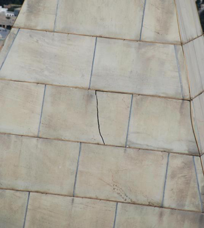
Damage to the Washington Monument from the 2011 Virginia earthquake (Credit: National Park Service)
Virginia schoolchildren aren’t taught where to seek shelter during earthquakes. Families and public officials are more concerned with fire and flooding than seismic activity. But in 2011, a rare earthquake rattled the nerves of Virginia residents and U.S. Geological Survey scientists in the state.
Nearly three years later, those scientists have installed a 20-station seismic monitoring network to learn why earthquakes sometimes occur in the least likely of places.
Emanating near Louisa and Mineral, Va., the August 2011 quake measured at 5.8 on the Richter scale, unusually strong for seismic activity in that area. The earthquake was felt from Georgia to Maine, and even as far west as Chicago.
“The 2011 earthquake woke up a lot of people to the fact that this is a big issue,” said Thomas Pratt, research geophysicist with the USGS in Reston, Va. “Earthquakes are a low probability, but much higher risk because the buildings here are not built to withstand them, and it’s so densely populated.”
Pratt and his colleagues understood that the five seismometers operating in the area at the time would not be able to provide the comprehensive data necessary to analyze the earthquake.
The decision to create a more accurate network started as a friendly discussion over drinks.
“In research there are a lot of personal connections,” Pratt said. “My colleagues and I were sitting and having a beer one day and asked what we could do to make this better.”
The solution, they decided, would require both an increase in quantity and sensitivity of the seismometers. The USGS researchers turned to the Incorporated Research Institutions for Seismology to obtain the instruments on loan for several months.
The team installed 20 Mark Products seismometers and REF TEK data loggers from Charlottesville to east of Richmond, Va. Each cylindrical seismometer is about six inches tall and four inches in diameter, with an appearance of a soda can, or “a really fat coin”. The instruments are buried one foot underground and attached to car batteries, AC adapters or solar panels for power. Data loggers kept in nearby containers record measurements taken every couple of milliseconds.
")
The seismometer network will help researcher better understand events like the 2011 Virginia earthquake that occur away from plate boundaries (Credit: U.S. Geological Survey)
With relatively little time to collect data, Pratt and the other researchers increased the seismometers’ sensitivity to produce more measurements.
“We’re trying to trade off detection for time,” Pratt said. “Fewer instruments take longer to detect quakes. It would take 100 years to measure enough earthquakes to figure out what’s really going on…But by lowering the magnitude [threshold] by two or three, we get 100, 200 times as many earthquakes.”
Any significant seismic motion is recorded by the network and placed in a database for further study. Although the seismometers will be in the ground for just a few months, Pratt said he hopes the loan can be extended to a few years — or even indefinitely.
“This is just kind of a test case,” Pratt said. “Let’s see how this works.”
Some of the recently installed seismometers are part of the EarthScope program, which monitors seismic activity across the country. The program’s network has 160 stations on the East Coast, but Pratt said more are needed.
Citing the 2011 event, as well as a destructive earthquake that struck Charleston, S.C., in 1886, Pratt said a number of uncommon — yet violent — quakes have hit the east and southeast regions of the U.S., leaving scientists baffled.
“It’s a real mystery what’s causing these earthquakes,” Pratt said. “We’re not on the edge of a plate — there shouldn’t be this kind of motion.”
“Once we understand these earthquakes, it will help us understand how we get [earthquakes] in other unusual areas,” he said.
Top image: Damage to the Washington Monument from the 2011 Virginia earthquake (Credit: National Park Service)


0 comments