
Monitoring the Sapelo Island National Estuarine Research Reserve
Much like coastal estuaries serve as nursery habitats for marine species, the waters around Sapelo Island on the Georgia coast have served as the nursery for the discipline of estuarine science.
“We’re probably the most studied body of estuarine water in the world, in the Duplin River,” said Dorset Hurley, research coordinator for the Sapelo Island National Estuarine Research Reserve. “Studies have been sponsored here for over 60 years now.”
R.J. Reynolds. Jr., a tobacco heir who owned the barrier island in the mid-1900s, founded the Sapelo Island Research Foundation in 1949 and funded scientists whose work contributed to the rise of modern ecology. Today, the island hosts the University of Georgia Marine Institute on its south end.
Along the western edge of the island, the 6,110-acre Sapelo Island National Estuarine Research Reserve is one of 28 sites across the country designated under the National Estuarine Research Reserve program administered by the National Oceanic and Atmospheric Administration.
As part of the program, the Georgia Department of Natural Resources is charged with operating the reserve as a living laboratory for scientific research and a source for education and training for the general population and local community officials on estuarine processes.
“These can range from sea level rise to issues related to water quality associated with anthropogenic development to just general estuarine science for K-12,” Hurley said. “It’s an extremely varied program.”
")
Beach water quality monitoring at the Sapelo NERR using a remote water quality probe in tandem with a captured water sample to qualify safety swimming standards for the public. (Credit: Sapelo NERR)
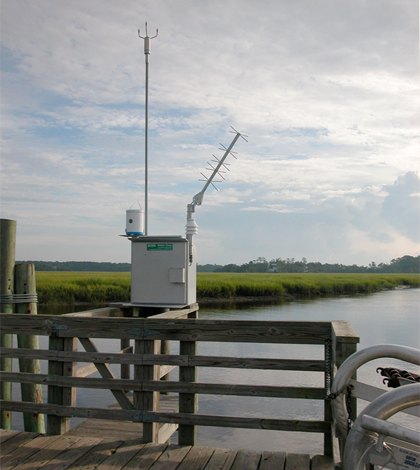
An important part of the reserve’s research mission is collecting high-quality scientific data for scientists to use free of charge. Some of that data comes from four water quality stations across the reserve equipped with YSI 6600 multi-parameter sondes measuring temperature, depth, turbidity, specific conductance, salinity, pH, dissolved oxygen concentration and percent saturation. A weather station supplies data on air temperature, wind speed and direction, relative humidity, precipitation, photosynthetically active radiation and barometric pressure.
Beyond the sensor data, the reserve also conducts monthly nutrient sampling and participates in a national atmospheric deposition program.
“We’re very heavy on these non-sexy, poorly supported but necessary background monitoring programs so that we can supply no cost, high quality estuarine water and weather quality data which promotes scientific studies within our reserve,” said Hurley. “That’s one of the missions of our national program.”
The high-resolution data is especially useful in the dynamic environment around Sapelo. The island sits at a spot on the Atlantic coast where the geometry of the shoreline and the low-sloping continental shelf lead to an average 8-foot difference between high tide and low tide. The shallow, well-mixed waters are subject to high turbidity and extreme temperature swings.
That variability has its upsides, including bolstering the system’s resilience against colonization from certain invasive species like the green porcelain crab. During a cold winter where water temperatures dropped below 15 degrees Celsius for a week or more, and a tributary river brought a large amount of fresh water into the estuary, monitored densities of the crab dropped from 3,500 per meter square to zero, Hurley said.
The variability can also bring headaches.
“We have a very, hyper-driven biological system functioning within that water column,” Hurley said. “And it creates conditions like biofouling that are the worst in the nation.”
As part of its mission to conduct research with tangible benefits for the local citizens and governments, researchers on the island are also concentrating on monitoring sea level rise. That data will help build training and education efforts on adaptation principles like resilient building practices.
“Preparedness and training for the best ways plan for issues related to tidal inundation processes, increased storm activity and things of this nature are very real to people who live on the Georgia coast,” Hurley said. “A lot of this is based upon monitoring data. So that’s where the rubber hits the road, when you start taking your information and applying it to needed policy development.”
The strength of Sapelo Island National Estuarine Research Reserve monitoring programs, Hurley said, lies in its partnerships. Its collaborators include NOAA, the state of Georgia, the Nature Conservancy and multiple universities.
“We’re getting information and feedback from all of these folks,” he said. “We are very issue-driven, and we want our monitoring to serve multiple facets. The ultimate goal is to monitor within an area and meet many partner needs simultaneously.”
Top image: GOES-satellite real-time satellite transmitted weather data at the Sapelo NERR (Credit: Sapelo Island National Estuarine Research Reserve)


0 comments