Sediment and Tree Rings Reveal Details of 500 Years of Floods—and Human Interference
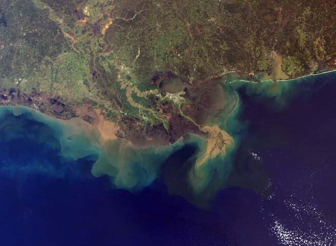
This is a true-color image, acquired from the Moderate Resolution Imaging Spectroradiometer (MODIS) aboard NASA’s Terra satellite on March 5, 2001. The sediment plume from the Mississippi River is at right, and the plume from the Atchafalaya River can be seen at the left. (Photo Credit: By See below [Public domain], via Wikimedia Commons.)
A 100-year flood sounds to laypeople like something that happens once each century, but the term really just refers to an extreme hydrologic event with a 100-year recurrence interval. In other words, it’s a flood whose magnitude reaches a level that has a one percent chance of happening in any given year.
This means they can happen more often than that—and a recent study from a team led by Woods Hole Oceanographic Institution (WHOI) researchers has revealed that along the Mississippi River, they are happening more frequently. The work is also providing insight into why human interference in the form of projects to channelize, straighten, and bound the water with artificial levees is causing such a notable increase in both the frequency and size of extreme flood events.
WHOI geoscientist Liviu Giosan, a lead member of the research team, and Sam Muñoz—a former WHOI postdoctoral scholar, the lead author of the study, and currently an assistant professor at Northeastern University—corresponded with EM about the research and the ways that the hand of human intervention has changed the face of flooding along the Mississippi River.
Taming the Mighty Mississippi
Various river engineering structures including dams regulate the Mississippi River Basin (MRB). These human-built modifications have produced a number of socioeconomic benefits, including a certain level of flood mitigation, simpler and faster navigation, bank stabilization, hydropower, and increased recreational opportunities. However, these came at a cost—one that is only beginning to be understood.
River engineering has transformed the ecologic, geomorphic, hydrologic, sediment transport, and water-quality characteristics of the Mississippi River and its delta. While the complex web of wing dikes, reservoirs, and levees that populates the MRB protects the region from floods of small and intermediate size, they have had the unintended effect of reducing the capacity of the channel overall and increasing the flood stage for higher magnitude floods by up to four meters.
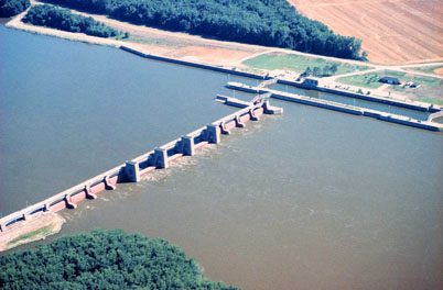
Mississippi River Lock and Dam number 17 near New Boston, Illinois. (Photo Credit: By USGS ([1] from [2]) [Public domain], via Wikimedia Commons.)
“A 100-year flood is, by definition, a flood of a magnitude that has a 1% chance of occurring in any given year,” explains Muñoz. “Our study shows that if you calculate what the 100-year flood was from AD 1500-1800 and compare that to what the 100-year flood is today, it is about 20% larger (in terms of discharge) today than in the past.”
The team discovered that about three-quarters of that change and the resulting elevated flood danger can be attributed in part to human river engineering in the MRB. To determine that, the researchers extracted long sediment cores from the bottoms of marshes and lakes in the region—a technique pioneered at WHOI. To do this, they deployed 30-foot-long aluminum tubes from pontoon boots.
“Oxbow lakes act like a trap for muddy floodwaters,” details Giosan. “When the river overflows its banks, the flood water brings sediment to these lakes that is coarser than the typical washout from around the lake. This provides a means to see the number of floods in a probabilistic sense.”
Large floods cause faster moving water to stir up larger-grained sediments that aren’t usually disturbed; that coarser mix then flows into the marshes and lakes which are usually disconnected from the river, carrying sediments. The flood current eventually deposits the river material which then sinks, a layer marking a flood event somewhere in the strata forming the floor of the lake. These layers tell the story of past floods, and as scientists dig deeper into the floor, they “read” a flood record from further into the past.
Nitty gritty
Analyses performed by the team also revealed, to the delight of the team, that sediment grain size is correlated with flood magnitude. This is, in some sense, intuitive; bigger floods generate more water and more energy, which stir up and deposit larger bits of sediment. The team compared known flood events with grain sizes in the record to nail down these patterns.
The researchers dated the layers of sediment using isotopes of carbon, cesium, and lead to ensure an accurate record of when major flood events happened. Because plant remains were very rare, they also used alternative methods to complement radiocarbon measurements. They analyzed the age of the materials using optically-stimulated luminescence, which determines when the substance was last exposed to sunlight. The team also looked into more recent flooding in the region using annual tree rings.
The idea was to use the tree rings to confirm the accuracy of the sediment cores as flood recorders; since the analyses were generally in agreement despite their independence, the team considers their sediment-based method to be trustworthy.
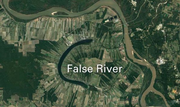
The research team collected cores of bottom sediments from three oxbow lakes to trace the history of major floods along the lower Mississippi River. Lakes such as this one (called False River) are former meanders that have become separated from the main river channel. During large floods, river water flows into them again, carrying suspended sediments that settle to the lake bottom — a ‘signature’ of flooding that researchers can identify. (Photo Credit: Google Earth, 2018, https://www.eurekalert.org/multimedia/pub/166753.php?from=389460 )
“Flood recording by tree rings is completely independent from flood recording in lakes,” remarks Giosan. “Although trees along the Mississippi do not live as long as we would like them to, they provide an important check on what we see in lakes. If the two independent methods agree, and they do, then we can trust them both and use the lakes to extend the record past the trees’ living range.”
The team also compared their findings with natural climatic cycles such as the El Niño-Southern Oscillation (ENSO). They discovered that the flood cycles of the Mississippi River corresponded with climate and ocean cycles. El Niño events, in particular, are likely to prompt flooding, as they bring more rainfall to central North America, and the ground surrounding the Mississippi becomes saturated. Given this connection between flood cycles and ocean and climate cycles, the team’s research may allow for more accurate prediction of flood events in the future.
“This is the most exciting piece of the story for me personally,” adds Giosan. “I have waited for 15 years now for a credible way to see back in time on how rivers change beyond what has been measured directly. Did their water discharge vary? Did their sediment load change? Did the floods character change? If we can look in the past, and it is clear from our study that at least for floods we can, then we can really start to ask how climate drives rivers. Predictions now are done by modeling using 100 years or of direct measurements. If we are able to better calibrate the models with longer reconstructions then we can have better predictions.”
Moving forward, the kinds of risks that can arise from river-engineering will need to be weighed against the benefits of conventional navigation and flood mitigation practices. This work may also support initiatives to restore parts of the Mississippi—to the extent that’s possible.
“Restoring natural patterns refers to changing back the frequency and magnitude of floods to their natural ranges; not everywhere this would be possible,” explains Giosan. “But one good example is the Mississippi Delta. Built levees run along the river in the delta to protect the navigation channel and human settlements. These levees are in large part responsible for the drowning of the delta—a natural disaster of national proportions that has already led to the first climate refugees in the US! Restoration there, by breaching the levees to let flood waters feed the marshes and keep them above sea level is possible and planned, but costly. It is also being done very timidly while the delta dies fast!”
Coming in the near future for the team: exploring the deep sedimentation of other rivers, helping to build a long-term historical record of flooding in other major world river systems—and extending what they already know about the Mississippi.
“There are many rivers across the world that have oxbows and we have plans for a few if we can get somebody to fund us for that,” states Giosan. “But we just started a new project that will hopefully extend the Mississippi record longer in time and add new records on its largest tributaries.”


0 comments