Sensors watch water quality near Folsom Dam spillway construction
Construciton underway on the Folsom Dam Auxiliary Spillway project (Credit: U.S. Army Corps of Engineers)
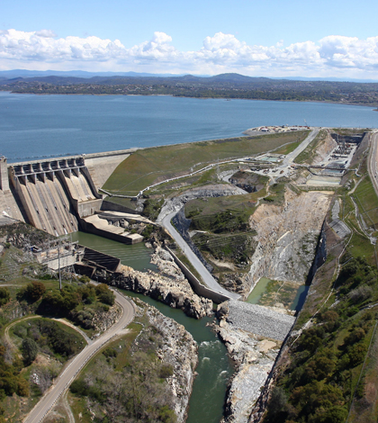
A construction project is underway on a Northern California dam to bolster flood protection for Sacramento region, an area federal agencies say is among the most at risk for flood damage in the United States. An engineering firm’s novel water quality monitoring strategy is helping to keep the operations on schedule while protecting the environment.
The Folsom Dam Auxiliary Spillway project is an approximately $900 million cooperative effort between the U.S. Army Corps of Engineers and the U.S. Department of the Interior’s Bureau of Reclamation that will help the Sacramento region achieve a 200-year level of flood protection. Work on the project on the American River includes a new spillway that will give operators of the Folsom Dam more flexibility in controlling the Folsom Lake reservoir’s level to make room for incoming flood waters ahead of storm events.
The project will involve removal and relocation of up to 1.2 million cubic yards of sediment and rock from the project area, including a significant amount of dredging and deposition of dredged material within Folsom Lake. Construction crews must meet state and federal environmental permit requirements, with a focus on water quality. Water clarity is is a particular concern, and should turbidity levels outside of the project area rise above the project’s Clean Water Act permit thresholds, a work stoppage would result.
Projects like this typically require manual spot sampling of water quality parameters like turbidity, dissolved oxygen, temperature and pH every four hours, according to John Spranza, senior consultant with Cardno ENTRIX, an environmental consulting firm. The firm is working on compliance issues for Kiewit Infrastructure West Co., the construction company contracted for the fourth of five phases on the spillway project.
Spot sampling is time-consuming and subject to error, both of which could be costly for a public safety project on a schedule. That’s especially the case on subalpine, Western Sierra lakes like Folsom where turbidity is naturally very low to begin with, which usually makes for strict shut-down thresholds.
")
NexSens buoys equipped with YSI sondes provide continuous water quality data in Folsom Lake (Credit: Mike Voellmecke)
That could make for situations where a $235 million dollar project responsible for the flood protection of 40 linear miles downstream is held up by faulty measurements showing artificially high levels of turbidity, Spranza said.
“That could simply be a fish swimming by and kicking up some type of material, some piece of algae getting lodged in there, a cigarette butt–something that the meter picks up,” he said. “It could be actual, or it could be an error.”
To avoid that sort of hangup while still keeping a close eye on the project’s environmental effects, Cardno ENTRIX has pioneered what they call an “Active Adaptive Management Plan,” a monitoring strategy that depends on “active” continuous water quality measurements and automated analysis of multiple instruments moored throughout the lake both upstream and downstream of the dredging site.
Three NexSens buoys moored in areas of Folsom Lake not affected by the job site carry YSI sondes that provide data on background conditions every 15 minutes. Another buoy and sonde downstream of the work area samples water under the influence of dredging operations. Under this setup, project managers can compare dredge-influenced water quality conditions against background levels to protect against false positives caused by equipment malfunctions or natural fluctuations brought on by storms or seasonal changes in lake conditions.
Data from the buoys are relayed back to a computer at the job site running NexSens iChart software, which calculates rolling averages and compiles reports every four hours and every 24 hours. The software will also send out alerts to project managers if a water quality constituent rises above a predetermined amount above background, triggering the “adaptive” elements of Cardno’s management plan. Rather than immediately shutting down work, crews get a chance to check for anomalies in the data and modify project operations prior to triggering a shutdown.
“You send someone out in the field to calibrate the instruments and make sure you don’t have a plastic trash bag wrapped around the monitor. We’ve seen little tiny fish that decided to take up residence inside of our instrument housing,” Spranza said. “All sorts of stuff that’s not project related but had we not had this system would have immediately stopped the project if a simple grab sample approach was used.”

An artist’s rendering of the completed Folsom Dam spillway (Credit: U.S. Bureau of Reclamation)
If the issue turns out not to be a fluke in the data, the crew gets a chance take preliminary steps to address the problem. For example, they’ll check that the sediment curtain around the dredge and deposition sites are working properly, or that there has not been a sudden change in background conditions. If they can’t address the source of the water quality concern, and it is identified as coming from the project, then Spranza works with the Kiewit project team, regulatory agencies and project partners to determine if the issue can be resolved, or if the project needs to be temporarily shut down while a solution is worked out.
But that hasn’t happened yet.
“When you have a robust dataset, it actually helps to keep the project moving,” Spranza said. “So far we’ve lost zero days of work due to water quality on this project, and they’re out there every day except for Sunday moving dirt.”
The Folsom dam, built in the 1950s, is part of the federal Central Valley Project, a water management plan that moves water for municipal and agricultural uses from northern California to drier regions of the state through a system of pumps, canals, reservoirs and other feats of engineering. The new spillway’s gates will sit 50 feet lower than those on the main dam, allowing flood-related drawdowns to begin earlier. The dam was originally built to pass up to 557,000 cubic feet of water per second. The new spillway will add the capacity to move another 300,000 cubic feet per second–more than three times the average flow rate of Niagara Falls.
One Comment
Leave a Reply


richard nelson
August 17, 2014 at 8:18 PM
I was born in folsom in 1957 .and im mad as hell they didn’t put in a parking lot at the dam like they us to have.it was the only place you could park for free and swim or just look at the lake.
do you know if they are any plans to put one in ???it looks like they have room to do it.iv talk to maybe a 1000 people and they all are mad as hell. any help??