
UAV campaign, novel sensor packages peer into changing Arctic Ocean ice dynamics
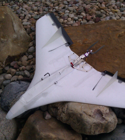
The Self Deployed Surface Sonde carries a 10-meter temperature string (Credit: Scott Palo/UC-Boulder)
Climate change has drastically altered the Arctic Ocean, where some areas have recently gone ice-free for the first time in human memory. Scientists say the changes there could have global consequences, but some regions of annual ice freeze-and-thaw are still poorly understood.
One of those regions is the marginal ice zone, the Arctic’s southernmost area of ice formation where melting is the most wide-spread. This past summer, a NASA-sponsored field campaign off the north coast of Alaska offered a first glimpse at how scientists could gain a better understanding of this important swatch of ocean using a suite of unmanned aircraft and novel data buoys.
In July and August, the Marginal Ice Zone Observations and Processes Experiment brought scientists from NASA, the National Oceanic and Atmospheric Administration, University of Alaska Fairbanks, University of Colorado Boulder and other universities to Oliktok Point on the Beaufort Sea.
From there, the scientists coordinated flights of a variety of unmanned aircraft to gather remotely sensed and in situ data during the summer melt period. That’s a crucial but especially understudied time in the Arctic, according to Scott Palo, professor of aerospace engineering sciences at the University of Colorado Boulder.
“With the opening up of the Arctic and the vast seasonal changes, the mechanisms of how thinner ice is created and destroyed is going to have a significant impact on helping to understand what the future ice dynamics are going to look like,” said Palo, who participated in the campaign. “Part of what we’re doing it trying to provide additional insight that can be used in modeling of ice dynamics and formation in the Arctic Ocean.”
Scientists have mostly relied on remote sensing instruments installed on aircraft or satellites to measure ice extent and sea surface temperatures. While those methods can cover a lot of water, they have some drawbacks. One is their coarse resolution. Another stems from gathering surface temperatures in areas where ice and water mix, which can result in muddled readings from an averaging of the two cover types. Those instruments are also limited to measuring the “skin temperature” of the ocean, analyzing the surface but missing what’s going on deeper in the water column.
The marginal ice zone campaign gave scientists a chance to test two UAV-based instruments developed at the University of Colorado, Boulder that could help address those issues. One was the Air-Deployed MicroBuoy, which Palo designed along with Dale Lawrence, an associate professor in the Aerospace Engineering Sciences Department. It’s a small buoy that supports a short string of temperature sensors designed to be launched from an unmanned aircraft.
“The whole package consists of a little battery, a microcontroller, a GPS and a little radio,” said Palo, who developed the buoy along with Dale Lawrence, an associate professor in the Aerospace Engineering Sciences Department. “And it fits into a physical package slightly larger than a roll of quarters.”
")
The Air Deployed MicroBuoy measures temperature at the surface and at depths of 1 and 2 meters (Credit: Scott Palo/UC-Boulder)
During the campaign, the researchers loaded the buoys into ScanEagle UAVs operated by the University of Alaska, Fairbanks. The aircraft would fly to a predetermined point offshore, drop a buoy and then hang around for a while and use its onboard receiver to make sure the instrument was working. Once in the water, the micro buoy’s temperature sensors took hourly measurements just below the surface and at depths of 1 and 2 meters. Those data were saved up until an AUV came by on another flight and uploaded a batch of measurements.
The researchers also tested the CU-Boulder-developed Self Deployed Surface Sonde, which consists of similar sensor equipment loaded into a small foam aircraft that can fly upwards of 20 kilometers offshore before landing and unfurling its 10-meter temperature string. Though this instrument’s limited battery capacity can’t carry its 18-inch wingspan as far offshore as a larger AUV with a micro buoy playload, it can achieve a more accurate placement than a buoy dropped from altitude.
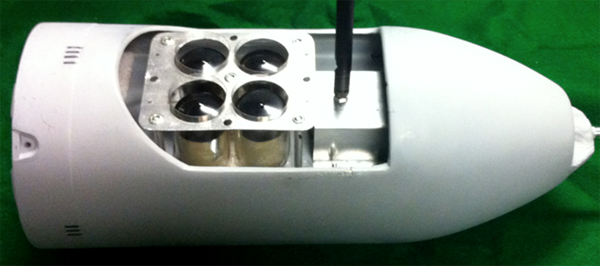
MicroBuoys loaded into a ScanEagle nose cone (Credit: Scott Palo/UC-Boulder)
The campaign gives scientists a chance to work through the challenges of sharing airspace among a variety of unmanned craft. They also worked collaboratively with the Federal Aviation Authority to develop some processes and procedures for managing UAVs. That will help guide future operations for these kinds of flight over the Arctic Ocean.
But the mission wasn’t just about working out the kinks for future UAV campaigns there. The scientists also brought back data that will help paint a clearer picture of ocean temperature and ice dynamics in the region.
“We’ve seen some very interesting structure in the data in terms of the gradient and the vertical temperature structure over the top 2 meters of the water column,” Palo said. “We’re in the processes of wrapping our head around that at the moment, and trying to get a better understanding of what that means.”


0 comments