USGS weather station network monitors Arctic Alaska’s climate
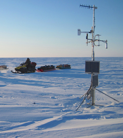
Snowmobile expedition checks on a weather station in the USGS polar Alaska climate and permafrost monitoring network (Credit: Frank Urban)
When the U.S. Geological Survey began building their climate and permafrost monitoring network in Arctic Alaska in 1998, there wasn’t much precedent for how to build the infrastructure for the instruments in the region’s unforgiving environment.
That meant the scientists had to learn the particulars on the fly. For example: On the great expanse of flat, barren tundra, a weather station sticks out like a sore thumb to a curious grizzly bear.
“The initial stations were pretty fragile,” said Frank Urban, a geologist with the USGS Geosciences and Environmental Change Science Center. “So the bear and those stations–the bear won every single time without any problem.”
Today, the sensors are cinched down tightly to steel or heavy aluminum tripods and the wires are encased in steel conduit to withstand the brute strength of bears. They’ve also had to overcome another problem more akin to keeping a squirrel out of a bird feeder, but in this case the pests are 30-pound carnivores.
“We have a lot of problems with wolverines up there,” Urban said. “They climb the stations, so we’ve had to work on making them less simple to climb.”
The result of all that work adapting to local fauna–not to mention high winds and extreme low temperatures–is an array of 16 climate and permafrost monitoring stations collecting continuous data across two tracts of federal land in northern Alaska.
The data collected by the network is particularly important because polar regions show the effects of climate change more dramatically and more quickly than other parts of the planet, Urban said. Yet the climate in regions like the Arctic National Wildlife Refuge and National Petroleum Reserve – Alaska has been poorly recorded. That’s mostly because it’s a remote and difficult place to work.
“There are very few if any roads and very few settlements and towns,” Urban said. “There haven’t been many people collecting spatially distributed environmental data, whether it’s temperature, or snowfall or rain until the last 10 or 15 years.”
")
A typical weather station in the network features an RM Young wind speed and direction sensor (Credit: Frank Urban)
The 16 stations measure standard climatic variables, including rainfall, air temperature and pressure, wind speed and direction, and snowpack depth and duration.
Another instrument measures subsurface permafrost temperatures at ten depths down to 1.2 meters. Yet at some sites, the permafrost runs as deep as 400 meters. The story of how deep permafrost is measured goes back to the 1970s, when the USGS worked with the U.S. Navy and private oil companies to drill exploratory wells in the National Petroleum Preserve – Alaska, Urban said. None of the wells produced oil, and a USGS researcher on the project had the foresight to suggest to prepare the wells in such a way that crews could return in the future and use them to measure permafrost temperatures.
And now they do.
“We have a winch that we bring and we send a very sensitive thermistor probe down into these boreholes,” Urban said. “By taking a set of temperature measurements every one to three years at these places, we can then build up a temperature history of deep permafrost.”

(Credit: Frank Urban)
Urban said he visits each site at least once a year, and sometimes twice a year. In the summer, the crews maneuver from site to site by helicopter and fixed-wing plane. In the spring, they’ll go on long snowmobile expeditions. In the Arctic National Wildlife Refuge, where they discourage motorized vehicles and the distances between sites aren’t as far, they’ll use dogsleds.
The stations are challenging to get to and the environment is difficult on the sensors and the researchers, but the work is fulfilling, Urban said.
“It’s pretty fun to do,” He said. “But it’s not like putting up a weather station in the field next to your house.”
Top image: A snowmobile expedition checks on a weather station in the USGS Arctic Alaska climate and permafrost monitoring network (Credit: Frank Urban)
One Comment
Leave a Reply


Pete
December 17, 2013 at 7:40 PM
I am wondering if the weather monitoring station on the Elliott highway near Livengood is a USGS station and how can one access the current conditions?
Thanks
Pete
mile 51 Elliott